1960s Maps of Twisp, Washington
Explore 4 historic maps of Twisp from the 1960s. These maps offer a rare glimpse into what life looked like during the 1960s — showing old roads, neighborhoods, homes, and landmarks that have changed or disappeared over time.
Whether you're researching your family's past, planning a metal detecting trip, or studying how Twisp's landscape evolved across the 1960s, these high-resolution maps are a powerful tool for exploring the history of this region.
- Focus on a specific era: All maps on this page are from the 1960s, giving you a focused view of this time period.
- See what’s changed: Compare century-old streets, trails, and buildings to today's modern landscape using overlays and satellite layers.
- Research with precision: Use these maps for genealogy, historical research, land use analysis, or educational projects.
- View, download, or print: Maps are fully viewable online in high resolution, and can be downloaded or printed for your own records.
Start exploring Twisp's history through authentic maps from the 1960s. This is your window into the past.
Twisp, WA maps
(4)- 1962 Map of Concrete
 1962 Concrete1962 Print · USGSThe Northern Cascades in the early sixties reveal a landscape of high alpine peaks and deep river valleys before the modern park era. Genealogists and historians can trace rail-and-river towns like Concrete, Darrington, and Stehekin, alongside industry at the Holden Mine.
 - 1969 Map of Twisp West, 1973 Print
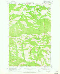 1969 Twisp West1973 Print · USGSIn the late 1960s, the mountainous terrain west of Twisp was a landscape of active mining and forest service outposts. Researchers can trace historic access routes via Pack Trails and locate significant industrial sites like the Alder Mine and the Lookout Tower atop Lookout Mtn.2 unique versions available
 - 1969 Map of Twisp, 1973 Print
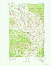 1969 Twisp1973 Print · USGSThe Methow Valley in the late sixties reveals a landscape of riverside settlements and upland mining claims. Genealogists can trace family names at Beaver Creek Cem or locate local landmarks like the Alder Mine and Allen Sch.
 - 1969 Map of Twisp East, 1973 Print
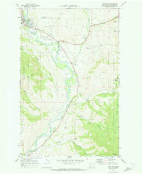 1969 Twisp East1973 Print · USGSThe Methow Valley in the late sixties shows a landscape of mountain lookouts and river-bottom industry. Trace family roots at Twisp and the Beaver Creek Cem, or locate mining history at the Minnie Mine and various Gravel Pits.
End of results
Showing maps 1-4 of 4
Top cities near Twisp
Frequently asked questions
- What are the different types of historical maps available for Twisp?
- What is the oldest map of Twisp?
- Where can I purchase historical maps of Twisp for my home or office?
- Where can I download high-res historical maps of Twisp?
- Are there historical topographic maps available for Twisp?
- Is there historical aerial imagery available for Twisp?
- Where are historical maps of Twisp sourced from?