2000-2009 Maps of Twisp, Washington
Explore 2 historic maps of Twisp from 2000-2009. These maps offer a rare glimpse into what life looked like during the 2000s — showing old roads, neighborhoods, homes, and landmarks that have changed or disappeared over time.
Whether you're researching your family's past, planning a metal detecting trip, or studying how Twisp's landscape evolved across the 2000s, these high-resolution maps are a powerful tool for exploring the history of this region.
- Focus on a specific era: All maps on this page are from the 2000s, giving you a focused view of this time period.
- See what’s changed: Compare century-old streets, trails, and buildings to today's modern landscape using overlays and satellite layers.
- Research with precision: Use these maps for genealogy, historical research, land use analysis, or educational projects.
- View, download, or print: Maps are fully viewable online in high resolution, and can be downloaded or printed for your own records.
Start exploring Twisp's history through authentic maps from the 2000s. This is your window into the past.
Twisp, WA maps
(2)- 2001 Map of Twisp East, 2004 Print
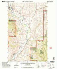 2001 Twisp East2004 Print · USGSThe Methow River valley near Twisp is captured here at the turn of the millennium, showing a landscape defined by water management and mountain wilderness. Researchers can identify local landmarks like the Beaver Creek Cem, the Allen Sch, and the high-altitude Mount Leecher Lookout.
 - 2002 Map of Twisp West, 2006 Print
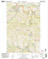 2002 Twisp West2006 Print · USGSThe Okanogan high country was a hub of prospecting activity at the turn of the millennium, centered on the rugged drainages of the Methow Valley. Researchers can trace old mining claims and remote mountain terrain, from the Alder Mine to the heights of Lookout Mtn and Lookout Ridge.
End of results
Showing maps 1-2 of 2
Top cities near Twisp
Frequently asked questions
- What are the different types of historical maps available for Twisp?
- What is the oldest map of Twisp?
- Where can I purchase historical maps of Twisp for my home or office?
- Where can I download high-res historical maps of Twisp?
- Are there historical topographic maps available for Twisp?
- Is there historical aerial imagery available for Twisp?
- Where are historical maps of Twisp sourced from?