1940s Maps of Nahcotta, Pacific County
Explore 2 historic maps of Nahcotta from the 1940s. These maps offer a rare glimpse into what life looked like during the 1940s — showing old roads, neighborhoods, homes, and landmarks that have changed or disappeared over time.
Whether you're researching your family's past, planning a metal detecting trip, or studying how Nahcotta's landscape evolved across the 1940s, these high-resolution maps are a powerful tool for exploring the history of this region.
- Focus on a specific era: All maps on this page are from the 1940s, giving you a focused view of this time period.
- See what’s changed: Compare century-old streets, trails, and buildings to today's modern landscape using overlays and satellite layers.
- Research with precision: Use these maps for genealogy, historical research, land use analysis, or educational projects.
- View, download, or print: Maps are fully viewable online in high resolution, and can be downloaded or printed for your own records.
Start exploring Nahcotta's history through authentic maps from the 1940s. This is your window into the past.
Nahcotta, Pacific County maps
(2)- 1943 Map of Copalis Beach
 1943 Copalis Beach1943 Print · USGSThe Washington coast in the 1940s is detailed here from the Olympic Peninsula to the Columbia River. Trace old beach settlements like Moclips and Copalis Beach alongside landmarks like the Willapa Bay Lighthouse.
 - 1949 Map of Ocean Park, 1955 Print
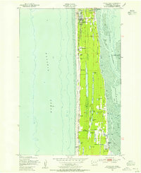 1949 Ocean Park1955 Print · USGSThe Long Beach Peninsula in the late 1940s was a landscape of coastal ranches, marshes, and small seaside communities. Researchers can trace the legacy of local families and industry through the Loomis Ranch, the Old Railroad Grade, and the Ocean Park-Nahcotta Sch.3 unique versions available
End of results
Showing maps 1-2 of 2
Frequently asked questions
- What are the different types of historical maps available for Nahcotta?
- What is the oldest map of Nahcotta?
- Where can I purchase historical maps of Nahcotta for my home or office?
- Where can I download high-res historical maps of Nahcotta?
- Are there historical topographic maps available for Nahcotta?
- Is there historical aerial imagery available for Nahcotta?
- Where are historical maps of Nahcotta sourced from?