1990s Maps of Alder, Washington
Explore 2 historic maps of Alder from the 1990s. These maps offer a rare glimpse into what life looked like during the 1990s — showing old roads, neighborhoods, homes, and landmarks that have changed or disappeared over time.
Whether you're researching your family's past, planning a metal detecting trip, or studying how Alder's landscape evolved across the 1990s, these high-resolution maps are a powerful tool for exploring the history of this region.
- Focus on a specific era: All maps on this page are from the 1990s, giving you a focused view of this time period.
- See what’s changed: Compare century-old streets, trails, and buildings to today's modern landscape using overlays and satellite layers.
- Research with precision: Use these maps for genealogy, historical research, land use analysis, or educational projects.
- View, download, or print: Maps are fully viewable online in high resolution, and can be downloaded or printed for your own records.
Start exploring Alder's history through authentic maps from the 1990s. This is your window into the past.
Alder, WA maps
(2)- 1990 Map of Eatonville, 1995 Print
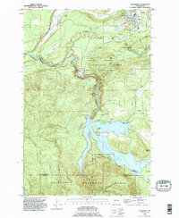 1990 Eatonville1995 Print · USGSEatonville and the Nisqually River valley appear here in the final decade of the millennium, defined by heavy timber research and massive hydro projects. Genealogists and local historians can trace the development of Alder, locate the Swanson Airport, and explore the bounds of the Charles Lathrop Pack Experimental Forest.
 - 1998 Map of Eatonville, 2003 Print
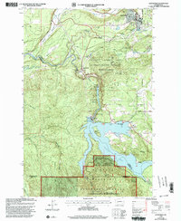 1998 Eatonville2003 Print · USGSThe Nisqually River corridor is shown here as it appeared in the late nineties, defined by the hydroelectric developments at Alder Lake and La Grande Reservoir. Researchers can trace the timber and research history of the Charles Lathrop Pack Demonstration Forest or locate landmarks like the Pack Lookout Tower and Little Mashel Falls.
End of results
Showing maps 1-2 of 2
Top cities near Alder
- Graham historical maps
- Elk Plain historical maps
- Eatonville historical maps
- Kapowsin historical maps
- Elbe historical maps
Frequently asked questions
- What are the different types of historical maps available for Alder?
- What is the oldest map of Alder?
- Where can I purchase historical maps of Alder for my home or office?
- Where can I download high-res historical maps of Alder?
- Are there historical topographic maps available for Alder?
- Is there historical aerial imagery available for Alder?
- Where are historical maps of Alder sourced from?