1990s Maps of Tacoma, Washington
Explore 7 historic maps of Tacoma from the 1990s. These maps offer a rare glimpse into what life looked like during the 1990s — showing old roads, neighborhoods, homes, and landmarks that have changed or disappeared over time.
Whether you're researching your family's past, planning a metal detecting trip, or studying how Tacoma's landscape evolved across the 1990s, these high-resolution maps are a powerful tool for exploring the history of this region.
- Focus on a specific era: All maps on this page are from the 1990s, giving you a focused view of this time period.
- See what’s changed: Compare century-old streets, trails, and buildings to today's modern landscape using overlays and satellite layers.
- Research with precision: Use these maps for genealogy, historical research, land use analysis, or educational projects.
- View, download, or print: Maps are fully viewable online in high resolution, and can be downloaded or printed for your own records.
Start exploring Tacoma's history through authentic maps from the 1990s. This is your window into the past.
Tacoma, WA maps
(7)- 1991 Map of Tacoma
 1991 Tacoma1991 Print · USGSThe South Sound and Tacoma waterfront appear here in the early nineties, showing a landscape defined by deep-water inlets and massive federal installations. Researchers can trace the development of Lakewood Center or locate the historic rail lines of the Burlington Northern Railroad and Union Pacific Railroad.
 - 1997 Map of Tacoma South, 2003 Print
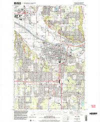
 1997 Tacoma South2003 Print · USGSTacoma and Pierce County are shown during a period of urban expansion in the late twentieth century. Researchers can trace the development of Parkland around Pacific Lutheran University or study the extensive grounds of Mc Chord Air Force Base.
 - 1997 Map of Poverty Bay, 2003 Print
 1997 Poverty Bay2003 Print · USGSCoastal development along the Puget Sound defines this late-nineties survey of the burgeoning Federal Way area. Genealogists and historians can trace family sites near Gethsemane Cemetery and older communities like Adelaide and Kitts Corner.
 - 1997 Map of Tacoma North, 2003 Print
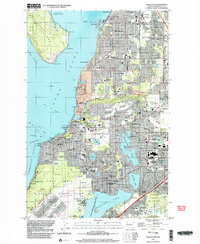
 1997 Tacoma North2003 Print · USGSThe industrial waterfront of Commencement Bay and the shores of Maury Island are captured in the late nineties, documenting a landscape of maritime commerce and island life. Trace the harbor's evolution through the Port of Tacoma, the Dash Point Lighthouse, and the historic Stadium High Sch.
 - 1997 Map of Puyallup, 2003 Print
 1997 Puyallup2003 Print · USGSPuyallup and the surrounding river valleys are shown in the late nineties as residential and commercial development accelerated across South Hill. Researchers can locate civic landmarks like the Western Washington State Fair Grounds and the Fort Maloney Historical Marker, alongside All Saints Ch.
 - 1997 Map of Steilacoom, 2003 Print
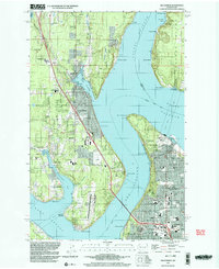
 1997 Steilacoom2003 Print · USGSSteilacoom and the surrounding lakeside communities are shown in great detail during the late 1990s as suburban life and military installations matured. Genealogists and local historians can locate many cemeteries, including Byrd Cem, and trace the grounds of the Western Washington State Hospital.
 - 1997 Map of Gig Harbor, 2003 Print
 1997 Gig Harbor2003 Print · USGSThe Gig Harbor peninsula and the Tacoma waterfront are shown here in the late nineties, connected by the iconic Tacoma Narrows Bridge. Genealogists and local historians can trace family-named sites and landmarks from Camp Sealth to Fort Nisqually.
End of results
Showing maps 1-7 of 7
Top cities near Tacoma
- Kent historical maps
- Renton historical maps
- Federal Way historical maps
- Auburn historical maps
- South Hill historical maps
- Lakewood historical maps
See more
Top neighborhoods of Tacoma
- Manitou historical maps
- Hillsdale historical maps
- Central Tacoma historical maps
- South End historical maps
- South Tacoma historical maps
- North End historical maps
See more
Frequently asked questions
- What are the different types of historical maps available for Tacoma?
- What is the oldest map of Tacoma?
- Where can I purchase historical maps of Tacoma for my home or office?
- Where can I download high-res historical maps of Tacoma?
- Are there historical topographic maps available for Tacoma?
- Is there historical aerial imagery available for Tacoma?
- Where are historical maps of Tacoma sourced from?