1960s Maps of Tacoma, Washington
Explore 6 historic maps of Tacoma from the 1960s. These maps offer a rare glimpse into what life looked like during the 1960s — showing old roads, neighborhoods, homes, and landmarks that have changed or disappeared over time.
Whether you're researching your family's past, planning a metal detecting trip, or studying how Tacoma's landscape evolved across the 1960s, these high-resolution maps are a powerful tool for exploring the history of this region.
- Focus on a specific era: All maps on this page are from the 1960s, giving you a focused view of this time period.
- See what’s changed: Compare century-old streets, trails, and buildings to today's modern landscape using overlays and satellite layers.
- Research with precision: Use these maps for genealogy, historical research, land use analysis, or educational projects.
- View, download, or print: Maps are fully viewable online in high resolution, and can be downloaded or printed for your own records.
Start exploring Tacoma's history through authentic maps from the 1960s. This is your window into the past.
Tacoma, WA maps
(6)- 1961 Map of Tacoma South, 1962 Print
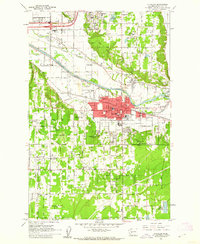
 1961 Tacoma South1962 Print · USGSSouthern Tacoma and its suburbs are shown during a period of rapid mid-century growth. Genealogists and local historians can locate long-standing institutions like Pacific Lutheran University, Oakwood Cem, and the historic Holy Rosary Sch.5 unique versions available
 - 1961 Map of Puyallup, 1962 Print
 1961 Puyallup1962 Print · USGSPierce County at the dawn of the 1960s shows a valley of rail lines and riverside settlements. Genealogists can trace family roots through Woodbine Cem and the many local schools like Firgrove Sch or Collins Sch.5 unique versions available
 - 1961 Map of Tacoma North, 1962 Print
 1961 Tacoma North1962 Print · USGSTacoma's industrial waterfront and the southern tip of Vashon Island are captured here during a period of significant mid-century growth. Researchers can trace the development of neighborhood schools like Lowell Sch or locate maritime landmarks such as the Dash Point Lighthouse and Browns Point.5 unique versions available
 - 1961 Map of Poverty Bay, 1962 Print
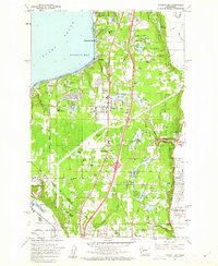 1961 Poverty Bay1962 Print · USGSThe Federal Way plateau and the King-Pierce county line are shown in the early sixties as suburban growth begins to surround historic shoreline communities. Researchers can trace the development of local schools, the Evergreen Airport, and the Auburn Cem alongside the Northern Pacific rail line.5 unique versions available
 - 1961 Map of Tacoma South, 1968 Print
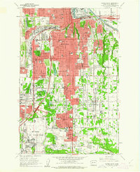
 1961 Tacoma South1968 Print · USGSPierce County during the early sixties shows the intersection of suburban growth and massive military infrastructure. Genealogists and historians can trace family plots like Henry Smith Cem, old airfields like Thun Field, and the campus of Pacific Lutheran University.
 - 1962 Map of Seattle
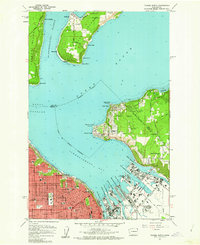
 1962 Seattle1962 Print · USGSThe Puget Sound region and Olympic Peninsula are shown at a peak of mid-century growth. Genealogists and historians can trace rail lines like the Pacific Coast RR or locate landmarks such as Fort Lawton and the Bothell Power Station.
End of results
Showing maps 1-6 of 6
Top cities near Tacoma
- Kent historical maps
- Renton historical maps
- Federal Way historical maps
- Auburn historical maps
- South Hill historical maps
- Lakewood historical maps
See more
Top neighborhoods of Tacoma
- Manitou historical maps
- Hillsdale historical maps
- Central Tacoma historical maps
- South End historical maps
- South Tacoma historical maps
- North End historical maps
See more
Frequently asked questions
- What are the different types of historical maps available for Tacoma?
- What is the oldest map of Tacoma?
- Where can I purchase historical maps of Tacoma for my home or office?
- Where can I download high-res historical maps of Tacoma?
- Are there historical topographic maps available for Tacoma?
- Is there historical aerial imagery available for Tacoma?
- Where are historical maps of Tacoma sourced from?