1900s (20th Century) Maps of College Camp, San Juan County
Explore 4 historic maps of College Camp from the 1900s (20th Century). These maps offer a rare glimpse into what life looked like during the 1900s — showing old roads, neighborhoods, homes, and landmarks that have changed or disappeared over time.
Whether you're researching your family's past, planning a metal detecting trip, or studying how College Camp's landscape evolved across the 1900s, these high-resolution maps are a powerful tool for exploring the history of this region.
- Focus on a specific era: All maps on this page are from the 1900s, giving you a focused view of this time period.
- See what’s changed: Compare century-old streets, trails, and buildings to today's modern landscape using overlays and satellite layers.
- Research with precision: Use these maps for genealogy, historical research, land use analysis, or educational projects.
- View, download, or print: Maps are fully viewable online in high resolution, and can be downloaded or printed for your own records.
Start exploring College Camp's history through authentic maps from the 1900s. This is your window into the past.
College Camp, San Juan County maps
(4)- 1954 Map of Waldron Island, 1957 Print
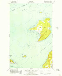 1954 Waldron Island1957 Print · USGSThe San Juan Islands remained a quiet maritime frontier in the mid-fifties, dominated by rocky shorelines and international waters. Trace the layout of the Waldron settlement, locate the island Cemetery, or find the Abandoned Quarry on the nearby cliffs of Orcas Island.4 unique versions available
 - 1957 Map of Victoria, 1960 Print
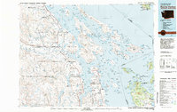
 1957 Victoria1960 Print · USGSThe San Juan Islands and the North Cascades coastline are shown in detail during the late fifties, a period of significant military and industrial presence. Researchers can trace historic rail lines like the Great Northern or locate sites such as the Whidbey Island Naval Air Sta and Friday Harbor.4 unique versions available
 - 1981 Map of Roche Harbor
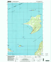
 1981 Roche Harbor1981 Print · USGSThe maritime boundary between the Gulf Islands and San Juans was well-established by the early eighties. Researchers can trace transportation routes like the Canadian Pacific Railway and find coastal settlements from Sidney to Ganges.2 unique versions available
 - 1997 Map of Waldron Island, 2003 Print
 1997 Waldron Island2003 Print · USGSWaldron Island remains an isolated community in the late nineties, anchored by its small post office and local boat docks. Researchers can trace land use through features like Sawmill Corner, the local Cem, and the Landing Strip.
End of results
Showing maps 1-4 of 4
Frequently asked questions
- What are the different types of historical maps available for College Camp?
- What is the oldest map of College Camp?
- Where can I purchase historical maps of College Camp for my home or office?
- Where can I download high-res historical maps of College Camp?
- Are there historical topographic maps available for College Camp?
- Is there historical aerial imagery available for College Camp?
- Where are historical maps of College Camp sourced from?