Old Maps of Nine Mile Falls, Washington
Explore 11 old maps of Nine Mile Falls, spanning from 1944 to today. These high-resolution historic maps reveal how streets, neighborhoods, landmarks, and natural features evolved over time — perfect for genealogy, metal detecting, research, and local history exploration.
What you can do with these maps:
- See how Nine Mile Falls changed over time: Compare historical maps to modern-day views to trace roads, homesites, rail lines & more.
- View detailed metadata: Each map includes creators, publishers, year, scale, and archive source.
- Overlay maps with satellite & LiDAR: Visualize the past alongside modern tools to explore terrain & human change.
- Trusted historical sources: Maps sourced from the USGS, Library of Congress, and other archives.
- Access maps your way: View online, download high-res files, or order prints for personal or research use.
Start exploring old maps of Nine Mile Falls to uncover forgotten places, hidden landmarks, and the deep history beneath your feet.
Nine Mile Falls, WA maps
(11)- 1944 Map of Clayton
 1944 Clayton1944 Print · USGSThe rural landscape north of Spokane is captured here just before the mid-forties, showing the vital river junctions and rail-connected settlements. Genealogists and researchers can trace local school districts and landmarks like Clayton, Haines Ranch, and the Spokane Indian Reservation.2 unique versions available
 - 1950 Map of Clayton, 1970 Print
 1950 Clayton1970 Print · USGSThe Stevens and Spokane county line in the mid-twentieth century shows a landscape of river-fed prairies and mountain peaks. Genealogists can locate family landmarks like Haines Ranch, Williams Valley Cem, and the Fort Spokane Historic Site.
 - 1955 Map of Spokane, 1965 Print
 1955 Spokane1965 Print · USGSInland Empire life in the fifties and sixties centers on the growth of Spokane and the heavy mining industry of northern Idaho. Trace mid-century landmarks like Fairchild Air Force Base, the Bunker Hill Mine, and early campuses such as Gonzaga University.2 unique versions available
 - 1958 Map of Spokane
 1958 Spokane1958 Print · USGSThe Inland Empire is shown at a mid-century peak of industrial and military activity, from the rail hubs of Spokane to the deep silver mines of northern Idaho. Researchers can trace the sprawling rail lines of the Union Pacific RR or locate landmarks like Fairchild Air Force Base and the Bunker Hill Smelter & Mine.
 - 1973 Map of Nine Mile Falls, 1977 Print
 1973 Nine Mile Falls1977 Print · USGSThe Spokane River valley in the early 1970s serves as a crossroads of frontier history and modern recreation. Local researchers can trace the early fur trade and military footprint at the Spokane House Historic Site and Fort Spokane Historic Site near Nine Mile Falls.2 unique versions available
 - 1987 Map of Spokane
 1987 Spokane1987 Print · USGSGreater Spokane and its surrounding prairies are captured in the late 1980s as the region solidified its role as a regional hub. Researchers can trace family sites near Medical Lake, military life at Fairchild Air Force Base, and rural settlements like Peone and Chattaroy.
 - 2011 Map of Nine Mile Falls, 2011 Print
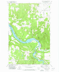
 2011 Nine Mile Falls2011 Print · USGSCovers Nine Mile Falls, including Spokane, Suncrest, and other nearby areas
 - 2014 Map of Nine Mile Falls, 2014 Print
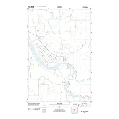
 2014 Nine Mile Falls2014 Print · USGSCovers Nine Mile Falls, including Spokane, Suncrest, and other nearby areas
 - 2017 Map of Nine Mile Falls, 2017 Print
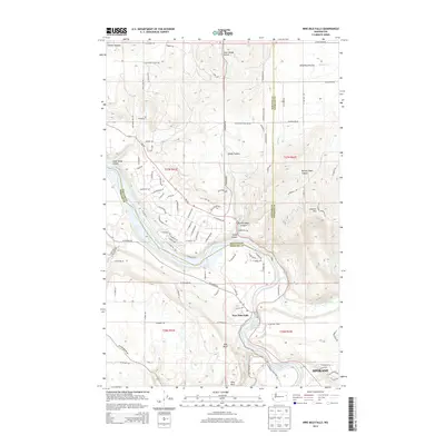
 2017 Nine Mile Falls2017 Print · USGSCovers Nine Mile Falls, including Spokane, Suncrest, and other nearby areas
 - 2020 Map of Nine Mile Falls, 2020 Print
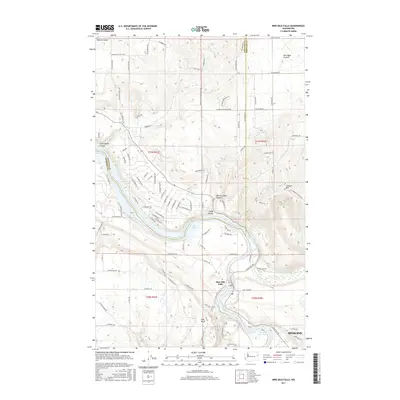
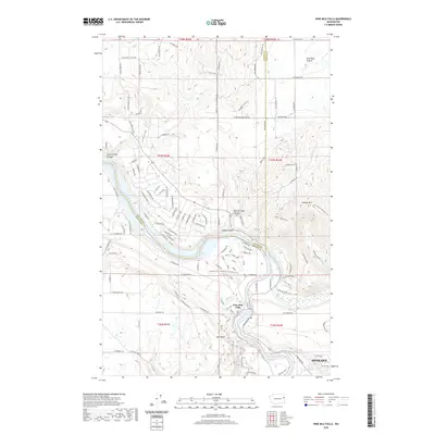 2020 Nine Mile Falls2020 Print · USGSCovers Nine Mile Falls, including Spokane, Suncrest, and other nearby areas
 - 2023 Map of Nine Mile Falls, 2023 Print
 2023 Nine Mile Falls2023 Print · USGSThe northern outskirts of Spokane and the winding river corridor are documented here in the early twenty-first century. Genealogists and local historians can trace developments in Suncrest, explore landmarks like Lookout Mtn, and locate old homestead routes near Wild Rose Prairie.
End of results
Showing maps 1-11 of 11
Top cities near Nine Mile Falls
- Spokane historical maps
- Spokane Valley historical maps
- Airway Heights historical maps
- Colbert historical maps
- Fairwood historical maps
- Mead historical maps
See more
Frequently asked questions
- What are the different types of historical maps available for Nine Mile Falls?
- What is the oldest map of Nine Mile Falls?
- Where can I purchase historical maps of Nine Mile Falls for my home or office?
- Where can I download high-res historical maps of Nine Mile Falls?
- Are there historical topographic maps available for Nine Mile Falls?
- Is there historical aerial imagery available for Nine Mile Falls?
- Where are historical maps of Nine Mile Falls sourced from?