1970s Maps of Dishman, Spokane Valley
Explore 2 historic maps of Dishman from the 1970s. These maps offer a rare glimpse into what life looked like during the 1970s — showing old roads, neighborhoods, homes, and landmarks that have changed or disappeared over time.
Whether you're researching your family's past, planning a metal detecting trip, or studying how Dishman's landscape evolved across the 1970s, these high-resolution maps are a powerful tool for exploring the history of this region.
- Focus on a specific era: All maps on this page are from the 1970s, giving you a focused view of this time period.
- See what’s changed: Compare century-old streets, trails, and buildings to today's modern landscape using overlays and satellite layers.
- Research with precision: Use these maps for genealogy, historical research, land use analysis, or educational projects.
- View, download, or print: Maps are fully viewable online in high resolution, and can be downloaded or printed for your own records.
Start exploring Dishman's history through authentic maps from the 1970s. This is your window into the past.
Dishman, Spokane Valley maps
(2)- 1973 Map of Spokane NE, 1975 Print
 1973 Spokane NE1975 Print · USGSSpokane and its eastern suburbs are shown here in the mid-1970s as industrial rail yards met growing residential neighborhoods. Trace local history through family-named cemeteries like Orchard Prairie Cem and the aviation legacy of Felts Field.3 unique versions available
 - 1978 Map of Spokane NE, 1981 Print
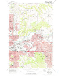
 1978 Spokane NE1981 Print · USGSEastern Washington urban development is on display in the late seventies as the Spokane suburbs expand. Researchers can trace the layout of Spokane neighborhoods and find localized landmarks like Dishman, Glenrose, and Little Baldy.
End of results
Showing maps 1-2 of 2
Frequently asked questions
- What are the different types of historical maps available for Dishman?
- What is the oldest map of Dishman?
- Where can I purchase historical maps of Dishman for my home or office?
- Where can I download high-res historical maps of Dishman?
- Are there historical topographic maps available for Dishman?
- Is there historical aerial imagery available for Dishman?
- Where are historical maps of Dishman sourced from?