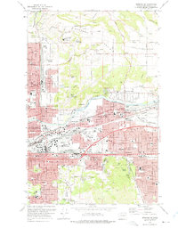
1973 Map of Spokane NE
USGS Topo · Published 1975About this map
Felts Field and the winding Spokane River anchor this 1970s landscape of rapid suburban expansion and industrial transport. The eastern edge of Spokane reveals a dense network of neighborhoods like Hillyard and Parkwater, deeply integrated with the heavy rail corridors of the Burlington Northern and the Spokane International railroads. To the north, the transition from urban streets to the open agricultural expanses of Orchard Prairie and Pleasant Prairie is marked by historic sites such as Mt St Michael and several rural burying grounds including Pleasant Prairie Cem.
Find a feature on this map
83 named features on this map. Tap any name to fly to it.
Don’t see what you’re looking for? This feature index may not catch every label — zoom into the map to look around manually.
Map Details
Editions of this 1973 Spokane NE Map
3 editions found
Other maps of this area

1901 · Spokane
USGS Topo · 1:125,000

1943 · Mt Spokane
USGS Topo · 1:62,500

1949 · Deer Park
USGS Topo · 1:62,500

1949 · Greenacres
USGS Topo · 1:62,500

1950 · Spokane NE
USGS Topo · 1:24,000

1950 · Spokane SE
USGS Topo · 1:24,000

1950 · Mt Spokane
USGS Topo · 1:62,500

1950 · Spokane SW
USGS Topo · 1:24,000

1950 · Spokane NW
USGS Topo · 1:24,000

1950 · Spokane
USGS Topo · 1:62,500