1970s Maps of Balboa / South Indian Trail, Spokane
Explore 2 historic maps of Balboa / South Indian Trail from the 1970s. These maps offer a rare glimpse into what life looked like during the 1970s — showing old roads, neighborhoods, homes, and landmarks that have changed or disappeared over time.
Whether you're researching your family's past, planning a metal detecting trip, or studying how Balboa / South Indian Trail's landscape evolved across the 1970s, these high-resolution maps are a powerful tool for exploring the history of this region.
- Focus on a specific era: All maps on this page are from the 1970s, giving you a focused view of this time period.
- See what’s changed: Compare century-old streets, trails, and buildings to today's modern landscape using overlays and satellite layers.
- Research with precision: Use these maps for genealogy, historical research, land use analysis, or educational projects.
- View, download, or print: Maps are fully viewable online in high resolution, and can be downloaded or printed for your own records.
Start exploring Balboa / South Indian Trail's history through authentic maps from the 1970s. This is your window into the past.
Balboa / South Indian Trail, Spokane maps
(2)- 1974 Map of Spokane NW, 1976 Print
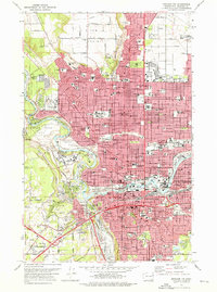 1974 Spokane NW1976 Print · USGSSpokane was a bustling hub of education, industry, and transit in the mid-seventies, centered on the Spokane River falls. Researchers can trace the legacy of local institutions like Gonzaga University or locate family plots in Holy Cross Cemetery and Greenwood Memorial Terrace.2 unique versions available
 - 1978 Map of Spokane NW, 1981 Print
 1978 Spokane NW1981 Print · USGSSpokane expanded toward the northern plateaus in the late 1970s, revealing a city defined by its relationship with the water. Trace the residential grid as it meets the bends of the Spokane River and the edges of Fivemile Prairie.
End of results
Showing maps 1-2 of 2
Frequently asked questions
- What are the different types of historical maps available for Balboa / South Indian Trail?
- What is the oldest map of Balboa / South Indian Trail?
- Where can I purchase historical maps of Balboa / South Indian Trail for my home or office?
- Where can I download high-res historical maps of Balboa / South Indian Trail?
- Are there historical topographic maps available for Balboa / South Indian Trail?
- Is there historical aerial imagery available for Balboa / South Indian Trail?
- Where are historical maps of Balboa / South Indian Trail sourced from?