1950s Maps of Goldfield Mill, Washington
Explore 2 historic maps of Goldfield Mill from the 1950s. These maps offer a rare glimpse into what life looked like during the 1950s — showing old roads, neighborhoods, homes, and landmarks that have changed or disappeared over time.
Whether you're researching your family's past, planning a metal detecting trip, or studying how Goldfield Mill's landscape evolved across the 1950s, these high-resolution maps are a powerful tool for exploring the history of this region.
- Focus on a specific era: All maps on this page are from the 1950s, giving you a focused view of this time period.
- See what’s changed: Compare century-old streets, trails, and buildings to today's modern landscape using overlays and satellite layers.
- Research with precision: Use these maps for genealogy, historical research, land use analysis, or educational projects.
- View, download, or print: Maps are fully viewable online in high resolution, and can be downloaded or printed for your own records.
Start exploring Goldfield Mill's history through authentic maps from the 1950s. This is your window into the past.
Goldfield Mill, WA maps
(2)- 1952 Map of Spirit, 1953 Print
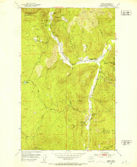 1952 Spirit1953 Print · USGSIn the early 1950s, the Stevens County mountains were an active hub for mineral extraction and forestry. Genealogists and historians can trace industrial landmarks like the Goldfield Mill and Copper King Mine alongside the South Fork Grange and Spirit School.5 unique versions available
 - 1958 Map of Sandpoint, 1966 Print
 1958 Sandpoint1966 Print · USGSThe Idaho Panhandle and Northeast Washington are shown here in the late fifties, when timber and hydroelectric power drove the local economy. Trace family roots in rail-side towns like Cusick or Metaline Falls, and locate landmarks like the Albeni Falls Dam or Falls Ranger Station.2 unique versions available
End of results
Showing maps 1-2 of 2
Top cities near Goldfield Mill
Frequently asked questions
- What are the different types of historical maps available for Goldfield Mill?
- What is the oldest map of Goldfield Mill?
- Where can I purchase historical maps of Goldfield Mill for my home or office?
- Where can I download high-res historical maps of Goldfield Mill?
- Are there historical topographic maps available for Goldfield Mill?
- Is there historical aerial imagery available for Goldfield Mill?
- Where are historical maps of Goldfield Mill sourced from?