Old Maps of Semiahmoo, Blaine for Metal Detecting
Plan your next treasure hunt with 4 historic maps of Semiahmoo. Find old homesites, ghost towns, trails, and gathering spots that may be lost to time — perfect for identifying promising metal detecting locations.
- Locate forgotten sites: Uncover places like long-lost settlements, abandoned rail lines, or gathering spots.
- Plan better hunts: Use map overlays combined with LiDAR or satellite views to narrow in on historically rich areas.
- Made for detectorists: Thousands of hobbyists use these maps to discover relics, coins, and hidden history.
Use these historic maps to boost your research and find new opportunities beneath the surface of Semiahmoo.
Semiahmoo, Blaine maps
(4)- 1952 Map of Birch Point, 1954 Print
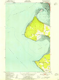 1952 Birch Point1954 Print · USGSThe northwestern tip of Washington state appears here in the early fifties, showing the coastal interface of the Strait of Georgia and Drayton Harbor. Researchers can trace the development of Semiahmoo, explore the rural roads leading to Cottonwood Beach, and locate family landmarks along Birch Point Rd.5 unique versions available
 - 1957 Map of Victoria, 1960 Print
 1957 Victoria1960 Print · USGSThe San Juan Islands and the North Cascades coastline are shown in detail during the late fifties, a period of significant military and industrial presence. Researchers can trace historic rail lines like the Great Northern or locate sites such as the Whidbey Island Naval Air Sta and Friday Harbor.4 unique versions available
 - 1975 Map of Bellingham, 1977 Print
 1975 Bellingham1977 Print · USGSNorthwest Washington in the mid-seventies is captured here, from the Canadian border at Blaine to the San Juan Islands. Researchers can trace tribal lands on the Lummi Indian Reservation, find rural settlements like Cokedale, or follow the Burlington Northern rail lines.
 - 2023 Map of Birch Point, 2023 Print
 2023 Birch Point2023 Print · USGSThis coastal corner of Whatcom County is shown in its contemporary state, where the waters of the Salish Sea meet established shore communities. Genealogists and locals can trace modern property developments near Semiahmoo and the historic reach of Drayton Harbor.
End of results
Showing maps 1-4 of 4
Top cities near Semiahmoo
Frequently asked questions
- What are the different types of historical maps available for Semiahmoo?
- What is the oldest map of Semiahmoo?
- Where can I purchase historical maps of Semiahmoo for my home or office?
- Where can I download high-res historical maps of Semiahmoo?
- Are there historical topographic maps available for Semiahmoo?
- Is there historical aerial imagery available for Semiahmoo?
- Where are historical maps of Semiahmoo sourced from?