1900s (20th Century) Maps of Mountain View, Washington
Explore 6 historic maps of Mountain View from the 1900s (20th Century). These maps offer a rare glimpse into what life looked like during the 1900s — showing old roads, neighborhoods, homes, and landmarks that have changed or disappeared over time.
Whether you're researching your family's past, planning a metal detecting trip, or studying how Mountain View's landscape evolved across the 1900s, these high-resolution maps are a powerful tool for exploring the history of this region.
- Focus on a specific era: All maps on this page are from the 1900s, giving you a focused view of this time period.
- See what’s changed: Compare century-old streets, trails, and buildings to today's modern landscape using overlays and satellite layers.
- Research with precision: Use these maps for genealogy, historical research, land use analysis, or educational projects.
- View, download, or print: Maps are fully viewable online in high resolution, and can be downloaded or printed for your own records.
Start exploring Mountain View's history through authentic maps from the 1900s. This is your window into the past.
Mountain View, WA maps
(6)- 1907 Map of Blaine
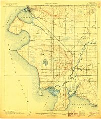 1907 Blaine1907 Print · USGSNorthwest Washington at the dawn of the twentieth century is defined here by the international border and the arrival of the rails. Genealogists and historians can trace the early layouts of Blaine, Ferndale, and Semiahmoo, alongside the Great Northern RR and the Lummi Indian Reservation.3 unique versions available
 - 1952 Map of Lummi Bay, 1957 Print
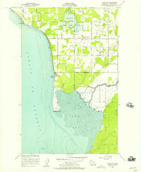 1952 Lummi Bay1957 Print · USGSThe coastal Lummi Indian Reservation meets the Strait of Georgia in the early fifties, showing a landscape of river flats and rising uplands. Trace family homesteads along Mt View Road or explore the mid-century shoreline at Neptune Beach and Sandy Point.4 unique versions available
 - 1952 Map of Blaine, 1960 Print
 1952 Blaine1960 Print · USGSCoastal Whatcom County is shown in the early fifties, from the international border at Blaine down to the Lummi Indian Reservation. Genealogists and local historians can trace rural schoolhouses like Whitehorn School, find family plots at Kulshan Cem, or locate the old Haynie Grange and Birch Bay Circle Grange.
 - 1957 Map of Victoria, 1960 Print
 1957 Victoria1960 Print · USGSThe San Juan Islands and the North Cascades coastline are shown in detail during the late fifties, a period of significant military and industrial presence. Researchers can trace historic rail lines like the Great Northern or locate sites such as the Whidbey Island Naval Air Sta and Friday Harbor.4 unique versions available
 - 1975 Map of Bellingham, 1977 Print
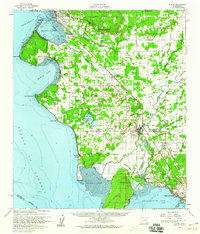
 1975 Bellingham1977 Print · USGSNorthwest Washington in the mid-seventies is captured here, from the Canadian border at Blaine to the San Juan Islands. Researchers can trace tribal lands on the Lummi Indian Reservation, find rural settlements like Cokedale, or follow the Burlington Northern rail lines.
 - 1997 Map of Lummi Bay, 2003 Print
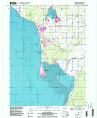 1997 Lummi Bay2003 Print · USGSCoastal Whatcom County shows a striking mix of heavy industry and reservation life during the late nineties. Researchers can trace the development of Sandy Point and the Refinery complex, or locate family sites near Mountain View Cem and the Lummi River.
End of results
Showing maps 1-6 of 6
Top cities near Mountain View
Frequently asked questions
- What are the different types of historical maps available for Mountain View?
- What is the oldest map of Mountain View?
- Where can I purchase historical maps of Mountain View for my home or office?
- Where can I download high-res historical maps of Mountain View?
- Are there historical topographic maps available for Mountain View?
- Is there historical aerial imagery available for Mountain View?
- Where are historical maps of Mountain View sourced from?