1960s Maps of Zillah, Washington
Explore 3 historic maps of Zillah from the 1960s. These maps offer a rare glimpse into what life looked like during the 1960s — showing old roads, neighborhoods, homes, and landmarks that have changed or disappeared over time.
Whether you're researching your family's past, planning a metal detecting trip, or studying how Zillah's landscape evolved across the 1960s, these high-resolution maps are a powerful tool for exploring the history of this region.
- Focus on a specific era: All maps on this page are from the 1960s, giving you a focused view of this time period.
- See what’s changed: Compare century-old streets, trails, and buildings to today's modern landscape using overlays and satellite layers.
- Research with precision: Use these maps for genealogy, historical research, land use analysis, or educational projects.
- View, download, or print: Maps are fully viewable online in high resolution, and can be downloaded or printed for your own records.
Start exploring Zillah's history through authentic maps from the 1960s. This is your window into the past.
Zillah, WA maps
(3)- 1961 Map of Yakima
 1961 Yakima1961 Print · USGSCentral Washington thrived in the mid-century as an agricultural powerhouse defined by the Yakima River. Trace local roots through Medicine Valley School, Fort Simcoe, and the rail lines of the Northern Pacific RR.
 - 1965 Map of Granger, 1966 Print
 1965 Granger1966 Print · USGSThe Yakima Valley thrived in the mid-sixties as a complex network of canals and railroads linked growing towns like Sunnyside and Granger. Researchers can trace the footprints of rural life at St Josephs Ch, Outlook Sch, and the settlement of Punkin Center.
 - 1965 Map of Granger NW, 1967 Print
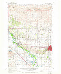
 1965 Granger NW1967 Print · USGSThe Yakima Valley in the mid-1960s reveals a landscape transformed by water management and rail transport. Trace the Roza Canal network, the Northern Pacific tracks, and family-named landmarks like Thacker Road or Zillah.
End of results
Showing maps 1-3 of 3
Top cities near Zillah
- Yakima historical maps
- Toppenish historical maps
- Union Gap historical maps
- Wapato historical maps
- Moxee historical maps
- Granger historical maps
See more
Top neighborhoods of Zillah
Frequently asked questions
- What are the different types of historical maps available for Zillah?
- What is the oldest map of Zillah?
- Where can I purchase historical maps of Zillah for my home or office?
- Where can I download high-res historical maps of Zillah?
- Are there historical topographic maps available for Zillah?
- Is there historical aerial imagery available for Zillah?
- Where are historical maps of Zillah sourced from?