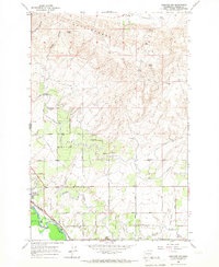
1965 Map of Granger NW
USGS Topo · Published 1967About this map
The Yakima River flows through the southwestern corner of this Yakima County landscape, which is defined by an extensive network of irrigation infrastructure and the rising Rattlesnake Hills to the north. In the mid-1960s, the irrigation systems of the Moxee Valley are visible in high detail, featuring the Roza Canal, Sunnyside Canal, and various secondary waterways like the Glacier Rd Canal and West Lateral Canal. These waterworks supported the agricultural development of the region, anchored by the town of Zillah and the smaller settlement at Punkin Center.
Find a feature on this map
46 named features on this map. Tap any name to fly to it.
Don’t see what you’re looking for? This feature index may not catch every label — zoom into the map to look around manually.
Map Details
Editions of this 1965 Granger NW Map
This is the sole edition of this map. No revisions or reprints were ever made.
Other maps of this area

1910 · Zillah
USGS Topo · 1:125,000

1936 · Yakima East
USGS Topo · 1:48,000

1936 · Hog Ranch Buttes
USGS Topo · 1:48,000

1941 · Black Rock Spring
USGS Topo · 1:62,500

1941 · Yakima East
USGS Topo · 1:62,500

1950 · Yakima
USGS Topo · 1:250,000
1953 · Black Rock Spring SW
USGS Topo · 1:24,000

1953 · Elephant Mountain
USGS Topo · 1:24,000
1953 · Black Rock Spring
USGS Topo · 1:24,000
1953 · Black Rock Spring
USGS Topo · 1:62,500