1960s Maps of Ansted, West Virginia
Explore 5 historic maps of Ansted from the 1960s. These maps offer a rare glimpse into what life looked like during the 1960s — showing old roads, neighborhoods, homes, and landmarks that have changed or disappeared over time.
Whether you're researching your family's past, planning a metal detecting trip, or studying how Ansted's landscape evolved across the 1960s, these high-resolution maps are a powerful tool for exploring the history of this region.
- Focus on a specific era: All maps on this page are from the 1960s, giving you a focused view of this time period.
- See what’s changed: Compare century-old streets, trails, and buildings to today's modern landscape using overlays and satellite layers.
- Research with precision: Use these maps for genealogy, historical research, land use analysis, or educational projects.
- View, download, or print: Maps are fully viewable online in high resolution, and can be downloaded or printed for your own records.
Start exploring Ansted's history through authentic maps from the 1960s. This is your window into the past.
Ansted, WV maps
(5)- 1961 Map of Charleston
 1961 Charleston1961 Print · USGSWest Virginia's capital region and the highlands to the east are shown in detail during the early sixties. Genealogists and historians can trace rail networks like the Baltimore and Ohio RR and find early state parks such as Watoga State Park.
 - 1969 Map of Fayetteville, 1972 Print
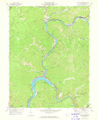
 1969 Fayetteville1972 Print · USGSThe New River Gorge area is documented here during the late sixties, showcasing a landscape defined by deep-canyon industry and plateau settlements. Researchers can trace the legacy of coal at Kaymoor No 1 or locate family sites at Huse Memorial Cem and Altamont Sch.3 unique versions available
 - 1969 Map of Beckwith, 1972 Print
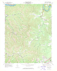 1969 Beckwith1972 Print · USGSFayette County was at its industrial peak in the late sixties, where coal mining and rail transport defined every valley. Genealogists and local historians can trace family-named sites and vanished industrial works from Beards Fork to the Harlem Heights Drive-in Theater and Lochgelly.2 unique versions available
 - 1969 Map of Ansted, 1973 Print
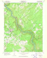
 1969 Ansted1973 Print · USGSThe coal and gas country of Fayette County comes to life in the late sixties, where the winding Gauley River meets the heavy rail of the Penn Central. Trace family roots through Ansted and smaller settlements like Victor or find local landmarks like Arnette Chapel and the Gauley Mtn Lookout Tower.2 unique versions available
 - 1969 Map of Gauley Bridge, 1973 Print
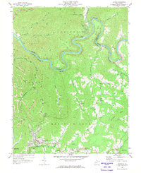
 1969 Gauley Bridge1973 Print · USGSIn the late 1960s, the confluence of the Gauley and New Rivers served as a vital industrial artery for West Virginia's rail and coal sectors. Researchers can pinpoint long-standing landmarks like Bailey Memorial Ch, trace the Penn Central tracks, and locate sites like K & M Junction and Glen Ferris.3 unique versions available
End of results
Showing maps 1-5 of 5
Top cities near Ansted
- Oak Hill historical maps
- Fayetteville historical maps
- Montgomery historical maps
- Mount Hope historical maps
- Gauley Bridge historical maps
- Boomer historical maps
See more
Frequently asked questions
- What are the different types of historical maps available for Ansted?
- What is the oldest map of Ansted?
- Where can I purchase historical maps of Ansted for my home or office?
- Where can I download high-res historical maps of Ansted?
- Are there historical topographic maps available for Ansted?
- Is there historical aerial imagery available for Ansted?
- Where are historical maps of Ansted sourced from?