1910s Maps of Leander, West Virginia
Explore 1 historic maps of Leander from the 1910s. These maps offer a rare glimpse into what life looked like during the 1910s — showing old roads, neighborhoods, homes, and landmarks that have changed or disappeared over time.
Whether you're researching your family's past, planning a metal detecting trip, or studying how Leander's landscape evolved across the 1910s, these high-resolution maps are a powerful tool for exploring the history of this region.
- Focus on a specific era: All maps on this page are from the 1910s, giving you a focused view of this time period.
- See what’s changed: Compare century-old streets, trails, and buildings to today's modern landscape using overlays and satellite layers.
- Research with precision: Use these maps for genealogy, historical research, land use analysis, or educational projects.
- View, download, or print: Maps are fully viewable online in high resolution, and can be downloaded or printed for your own records.
Start exploring Leander's history through authentic maps from the 1910s. This is your window into the past.
Leander, WV maps
(1)- 1910 Map of Fayetteville
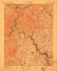 1910 Fayetteville1910 Print · USGSThe West Virginia coalfields were in full operation when this survey was conducted, showing the dense rail networks along the Gauley River. Local historians can trace family-named sites and industrial hamlets like Nuttallburg, Gauley Bridge, and Kaymoor.4 unique versions available
End of results
Showing maps 1-1 of 1
Top cities near Leander
- Oak Hill historical maps
- Summersville historical maps
- Fayetteville historical maps
- Ansted historical maps
- Rainelle historical maps
- Gauley Bridge historical maps
See more
Frequently asked questions
- What are the different types of historical maps available for Leander?
- What is the oldest map of Leander?
- Where can I purchase historical maps of Leander for my home or office?
- Where can I download high-res historical maps of Leander?
- Are there historical topographic maps available for Leander?
- Is there historical aerial imagery available for Leander?
- Where are historical maps of Leander sourced from?