1960s Maps of Powellton, West Virginia
Explore 4 historic maps of Powellton from the 1960s. These maps offer a rare glimpse into what life looked like during the 1960s — showing old roads, neighborhoods, homes, and landmarks that have changed or disappeared over time.
Whether you're researching your family's past, planning a metal detecting trip, or studying how Powellton's landscape evolved across the 1960s, these high-resolution maps are a powerful tool for exploring the history of this region.
- Focus on a specific era: All maps on this page are from the 1960s, giving you a focused view of this time period.
- See what’s changed: Compare century-old streets, trails, and buildings to today's modern landscape using overlays and satellite layers.
- Research with precision: Use these maps for genealogy, historical research, land use analysis, or educational projects.
- View, download, or print: Maps are fully viewable online in high resolution, and can be downloaded or printed for your own records.
Start exploring Powellton's history through authentic maps from the 1960s. This is your window into the past.
Powellton, WV maps
(4)- 1961 Map of Charleston
 1961 Charleston1961 Print · USGSWest Virginia's capital region and the highlands to the east are shown in detail during the early sixties. Genealogists and historians can trace rail networks like the Baltimore and Ohio RR and find early state parks such as Watoga State Park.
 - 1965 Map of Montgomery, 1966 Print
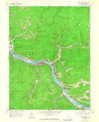 1965 Montgomery1966 Print · USGSThe Kanawha River valley was a humming corridor of coal and rail in the 1960s, with towns like Montgomery and London tightly squeezed between the water and the ridges. Genealogists and historians can trace the industrial footprint of Alloy, find rural landmarks like St Anthony Ch, or locate the London Lock & Dam No 3.2 unique versions available
 - 1965 Map of Powellton, 1966 Print
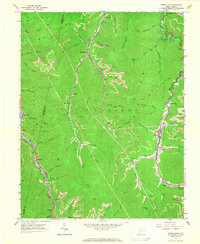 1965 Powellton1966 Print · USGSThe Fayette and Kanawha County border comes alive in the mid-sixties, showing a landscape defined by coal mining and heavy rail. Trace family roots and industrial sites from the tipple at Mahan to the cemeteries at Johnson Cem and Meadow Haven Memorial Park.2 unique versions available
 - 1969 Map of Beckwith, 1972 Print
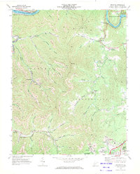 1969 Beckwith1972 Print · USGSFayette County was at its industrial peak in the late sixties, where coal mining and rail transport defined every valley. Genealogists and local historians can trace family-named sites and vanished industrial works from Beards Fork to the Harlem Heights Drive-in Theater and Lochgelly.2 unique versions available
End of results
Showing maps 1-4 of 4
Top cities near Powellton
- Oak Hill historical maps
- Fayetteville historical maps
- Montgomery historical maps
- Ansted historical maps
- Chesapeake historical maps
- Mount Hope historical maps
See more
Top neighborhoods of Powellton
- Eagle historical maps
- Montgomery Heights historical maps
- Columbia historical maps
- Elkridge historical maps
- McDunn historical maps
- Kimberly historical maps
Frequently asked questions
- What are the different types of historical maps available for Powellton?
- What is the oldest map of Powellton?
- Where can I purchase historical maps of Powellton for my home or office?
- Where can I download high-res historical maps of Powellton?
- Are there historical topographic maps available for Powellton?
- Is there historical aerial imagery available for Powellton?
- Where are historical maps of Powellton sourced from?