1930s Maps of Underwood Estates, Lewisburg
Explore 2 historic maps of Underwood Estates from the 1930s. These maps offer a rare glimpse into what life looked like during the 1930s — showing old roads, neighborhoods, homes, and landmarks that have changed or disappeared over time.
Whether you're researching your family's past, planning a metal detecting trip, or studying how Underwood Estates's landscape evolved across the 1930s, these high-resolution maps are a powerful tool for exploring the history of this region.
- Focus on a specific era: All maps on this page are from the 1930s, giving you a focused view of this time period.
- See what’s changed: Compare century-old streets, trails, and buildings to today's modern landscape using overlays and satellite layers.
- Research with precision: Use these maps for genealogy, historical research, land use analysis, or educational projects.
- View, download, or print: Maps are fully viewable online in high resolution, and can be downloaded or printed for your own records.
Start exploring Underwood Estates's history through authentic maps from the 1930s. This is your window into the past.
Underwood Estates, Lewisburg maps
(2)- 1935 Map of White Sulphur Springs, 1965 Print
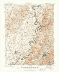 1935 White Sulphur Springs1965 Print · USGSGreenbrier County is shown here in the mid-1930s, featuring a landscape of mountain ridges and river-bottom settlements connected by the Chesapeake and Ohio railroad. Researchers can locate many now-rare landmarks, from Camp Alleghany to the Enon Church and schools like Dansie School.
 - 1939 Map of White Sulphur Springs
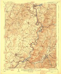 1939 White Sulphur Springs1939 Print · USGSGreenbrier County is captured here in the late 1930s, showing a landscape defined by the winding Greenbrier River and the expanding road network of Lewisburg. Genealogists and historians can trace numerous rural institutions, from the grounds of Camp Alleghany to local centers like Frankford and Pilgrim Rest Church.2 unique versions available
End of results
Showing maps 1-2 of 2
Top cities near Underwood Estates
- Lewisburg historical maps
- White Sulphur Springs historical maps
- Fairlea historical maps
- Ronceverte historical maps
- Union historical maps
- Falling Spring historical maps
Frequently asked questions
- What are the different types of historical maps available for Underwood Estates?
- What is the oldest map of Underwood Estates?
- Where can I purchase historical maps of Underwood Estates for my home or office?
- Where can I download high-res historical maps of Underwood Estates?
- Are there historical topographic maps available for Underwood Estates?
- Is there historical aerial imagery available for Underwood Estates?
- Where are historical maps of Underwood Estates sourced from?