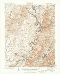
1935 Map of White Sulphur Springs
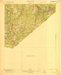
USGS Topo · Published 1965About this map
Greenbrier River meanders through this portion of West Virginia, serving as the central artery for a landscape defined by sharp ridges and deep mountain hollows. The prominent settlement of Lewisburg stands as a primary hub, surrounded by smaller communities such as Frankford, Williamsburg, and Ronceverte. The terrain is marked by distinctive elevations like Coles Mountain and Anthony Creek Mountain, while the Chesapeake and Ohio railroad corridor follows the river's path, highlighting the importance of rail transport in this era.
Find a feature on this map
78 named features on this map. Tap any name to fly to it.
Don’t see what you’re looking for? This feature index may not catch every label — zoom into the map to look around manually.
Map Details
Editions of this 1935 White Sulphur Springs Map
This is the sole edition of this map. No revisions or reprints were ever made.
Other maps of this area

1887 · Hinton
USGS Topo · 1:125,000

1887 · Lewisburg
USGS Topo · 1:125,000

1889 · Nicholas
USGS Topo · 1:125,000

1891 · Lewisburg
USGS Topo · 1:125,000

1891 · Nicholas
USGS Topo · 1:125,000

1891 · Huntersville
USGS Topo · 1:125,000

1892 · Hinton
USGS Topo · 1:125,000

1894 · Huntersville
USGS Topo · 1:125,000

1901 · Nicholas
USGS Topo · 1:125,000
1918 · Richwood
USGS Topo · 1:62,500