1990s Maps of Trainer, West Virginia
Explore 1 historic maps of Trainer from the 1990s. These maps offer a rare glimpse into what life looked like during the 1990s — showing old roads, neighborhoods, homes, and landmarks that have changed or disappeared over time.
Whether you're researching your family's past, planning a metal detecting trip, or studying how Trainer's landscape evolved across the 1990s, these high-resolution maps are a powerful tool for exploring the history of this region.
- Focus on a specific era: All maps on this page are from the 1990s, giving you a focused view of this time period.
- See what’s changed: Compare century-old streets, trails, and buildings to today's modern landscape using overlays and satellite layers.
- Research with precision: Use these maps for genealogy, historical research, land use analysis, or educational projects.
- View, download, or print: Maps are fully viewable online in high resolution, and can be downloaded or printed for your own records.
Start exploring Trainer's history through authentic maps from the 1990s. This is your window into the past.
Trainer, WV maps
(1)- 1995 Map of Lake Sherwood, 1998 Print
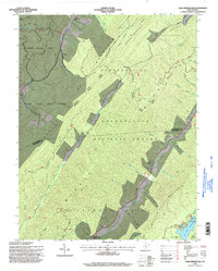 1995 Lake Sherwood1998 Print · USGSThe West Virginia high country in the mid-nineties is documented here as a vast network of state and federal forest lands. Researchers can locate secluded sites such as Columbia Sulphur Springs, May Chapel, and the remote Landing Strip near the Greenbrier County line.
End of results
Showing maps 1-1 of 1
Top cities near Trainer
- Clifton Forge historical maps
- Marlinton historical maps
- Hot Springs historical maps
- Hillsboro historical maps
Frequently asked questions
- What are the different types of historical maps available for Trainer?
- What is the oldest map of Trainer?
- Where can I purchase historical maps of Trainer for my home or office?
- Where can I download high-res historical maps of Trainer?
- Are there historical topographic maps available for Trainer?
- Is there historical aerial imagery available for Trainer?
- Where are historical maps of Trainer sourced from?