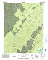
1995 Map of Lake Sherwood
USGS Topo · Published 1998About this map
Anthony Creek winds through a landscape dominated by the high ridges of Monongahela National Forest and Watoga State Park. This mid-1990s revision reveals a region defined by its conservation areas and recreational hydrology, centered on the recreational facilities at Lake Sherwood. Small-scale infrastructure like the Sewage Disposal Plant and a remote Landing Strip serve this forested interior, while the winding Anthony Creek is fed by numerous tributaries including Meadow Creek and Fallen Timber Run.
Find a feature on this map
58 named features on this map. Tap any name to fly to it.
Don’t see what you’re looking for? This feature index may not catch every label — zoom into the map to look around manually.
Map Details
Editions of this 1995 Lake Sherwood Map
This is the sole edition of this map. No revisions or reprints were ever made.
Other maps of this area

1887 · Lewisburg
USGS Topo · 1:125,000

1891 · Lewisburg
USGS Topo · 1:125,000

1891 · Huntersville
USGS Topo · 1:125,000

1894 · Huntersville
USGS Topo · 1:125,000

1894 · Natural Bridge
USGS Topo · 1:125,000

1901 · Monterey
USGS Topo · 1:125,000

1921 · Callaghan
USGS Topo · 1:48,000

1923 · Marlinton
USGS Topo · 1:48,000

1923 · Warm Springs
USGS Topo · 1:48,000

1923 · Callaghan
USGS Topo · 1:62,500