1990s Maps of Hardy County, West Virginia
Explore 8 historic maps of Hardy County from the 1990s. These maps offer a rare glimpse into what life looked like during the 1990s — showing old roads, neighborhoods, homes, and landmarks that have changed or disappeared over time.
Whether you're researching your family's past, planning a metal detecting trip, or studying how Hardy County's landscape evolved across the 1990s, these high-resolution maps are a powerful tool for exploring the history of this region.
- Focus on a specific era: All maps on this page are from the 1990s, giving you a focused view of this time period.
- See what’s changed: Compare century-old streets, trails, and buildings to today's modern landscape using overlays and satellite layers.
- Research with precision: Use these maps for genealogy, historical research, land use analysis, or educational projects.
- View, download, or print: Maps are fully viewable online in high resolution, and can be downloaded or printed for your own records.
Start exploring Hardy County's history through authentic maps from the 1990s. This is your window into the past.
Hardy County, WV maps
(8)- 1994 Map of Lost City, 1997 Print
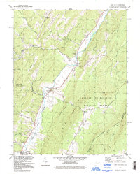 1994 Lost City1997 Print · USGSHardy County life in the 1990s is centered here along the banks of the Lost River as it passes through the valley. Researchers can trace rural lineages through numerous community landmarks, including New Dale Cem, Holly Hill Church, and the settlement of Mathias.
 - 1994 Map of Bergton, 1997 Print
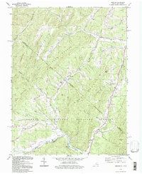 1994 Bergton1997 Print · USGSRockingham County and the West Virginia borderlands are documented here during the mid-nineties as the rural landscape of the Shenandoah Valley meets the mountain ridges. Researchers can trace local genealogy through sites like Bergton Sch, Jenkins Chapel, and the family-named hollows along Crab Run.
 - 1994 Map of Lost River State Park, 1997 Print
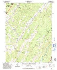
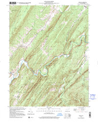
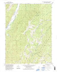 1994 Lost River State Park1997 Print · USGSHardy County highlands appear in high detail during the mid-to-late twentieth century, showcasing the development of Lost River State Park. Genealogists and hikers can trace the geography of Mathias and locate landmarks like Buckhorn Church and the Big Ridge Lookout Tower.
 - 1994 Map of Wolf Gap, 1997 Print
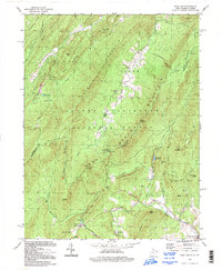 1994 Wolf Gap1997 Print · USGSThe Hardy and Shenandoah county border comes into focus in the mid-nineties, showing a landscape shaped by ridge-and-valley topography and early industry. Trace the legacy of iron production at Liberty Furnace or explore the mountain trails leading to Big Schloss and Trout Pond.
 - 1994 Map of Orkney Springs, 1997 Print
 1994 Orkney Springs1997 Print · USGSThe Shenandoah mountainside during the late twentieth century reveals a landscape of quiet resorts and deep-rooted forest camps. Genealogists and historians can trace family locations near Orkney Springs, Hepners, and the Cove Chapel burial grounds.
 - 1994 Map of Woodstock, 1997 Print
 1994 Woodstock1997 Print · USGSThe Shenandoah Valley and the rugged ridges of the national forest are captured here in the mid-1990s. Genealogists and historians can trace families across the settlements of St Luke and Alonzaville, or locate landmarks like Van Buren Furnace and Massanutten Military Academy.
 - 1995 Map of Mozer, 1998 Print
 1995 Mozer1998 Print · USGSPendleton and Grant counties are captured in the mid-1990s, showing a landscape of high ridges and narrow valley settlements. Genealogists and hikers can trace the rural homes and mountain gaps near Mozer, Mt Horeb Ch, and the rugged peaks of Cave Mtn.
 - 1999 Map of Baker, 2001 Print
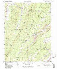
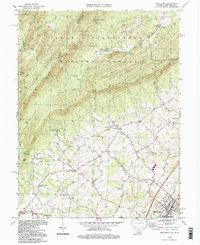
 1999 Baker2001 Print · USGSHardy County's steep ridges and river valleys are captured here as they appeared at the turn of the millennium. Researchers can trace historic family locations at Baughman Settlement, visit the Old Iron Furnace, and locate the Baker Sch and Mt Moriah Ch.
End of results
Showing maps 1-8 of 8
Top cities of Hardy County
Frequently asked questions
- What are the different types of historical maps available for Hardy County?
- What is the oldest map of Hardy County?
- Where can I purchase historical maps of Hardy County for my home or office?
- Where can I download high-res historical maps of Hardy County?
- Are there historical topographic maps available for Hardy County?
- Is there historical aerial imagery available for Hardy County?
- Where are historical maps of Hardy County sourced from?