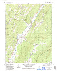
1994 Map of Lost City
USGS Topo · Published 1997About this map
The Lost River carves a narrow, fertile valley through the ridges of Hardy County, defining the settlement patterns of this Appalachian corridor in the mid-1990s. This survey captures the small communities of Lost City and Mathias as they appeared decades ago, anchored by local institutions like the Holly Hill Church and Lost River Ch. The landscape is a mix of high-elevation conservation and valley agriculture, with the Lost River State Park and George Washington National Forest buffering the human settlements. Notable family and community landmarks such as Cedar Hill Cem and Greenwood Cem offer significant value for genealogists tracking local history. The map also documents the industrial presence of a Quarry and a persistent energy pipeline that runs parallel to the river, illustrating the intersection of natural resources and infrastructure within the Big Ridge and Cove Mountain terrain.
Find a feature on this map
48 named features on this map. Tap any name to fly to it.
Don’t see what you’re looking for? This feature index may not catch every label — zoom into the map to look around manually.
Map Details
Editions of this 1994 Lost City Map
This is the sole edition of this map. No revisions or reprints were ever made.
Other maps of this area

1891 · Romney
USGS Topo · 1:125,000

1892 · Woodstock
USGS Topo · 1:125,000

1920 · Moorefield
USGS Topo · 1:62,500

1921 · Orkney Springs
USGS Topo · 1:48,000

1921 · Moorefield
USGS Topo · 1:48,000

1922 · Moorefield
USGS Topo · 1:62,500

1922 · Wardensville
USGS Topo · 1:62,500

1923 · Orkney Springs
USGS Topo · 1:62,500

1923 · Edinburg
USGS Topo · 1:62,500

1924 · Wardensville
USGS Topo · 1:62,500