
1923 Map of Orkney Springs
USGS Topo · Published 1923About this map
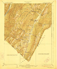
Lost River flows through a series of parallel ridges in Hardy County, West Virginia, carving a valley between South Branch Mountain and Lost River Mountain. In the early 1920s, this landscape was defined by a dense network of mountain-side schoolhouses and country churches serving dispersed rural communities. Settlements like Mathias, Lost City, and Basore act as focal points within the George Washington National Forest, while the presence of the Lumber RR along the Moorefield River in the northwest corner highlights the importance of the timber industry to the local economy. The mapping of family-named features such as Halterman School, Strawderman School, and Jenkins Chapel provides a high level of genealogical detail, showing the specific locations of community centers in the Appalachian highlands along the West Virginia Virginia border.
Find a feature on this map
61 named features on this map. Tap any name to fly to it.
Don’t see what you’re looking for? This feature index may not catch every label — zoom into the map to look around manually.
Map Details
Editions of this 1923 Orkney Springs Map
2 editions found
Other maps of this area

1891 · Romney
USGS Topo · 1:125,000

1892 · Franklin
USGS Topo · 1:125,000

1892 · Woodstock
USGS Topo · 1:125,000

1895 · Piedmont
USGS Topo · 1:125,000

1896 · Franklin
USGS Topo · 1:125,000

1920 · Petersburg
USGS Topo · 1:48,000

1920 · Moorefield
USGS Topo · 1:62,500

1921 · Orkney Springs
USGS Topo · 1:48,000

1921 · Petersburg
USGS Topo · 1:48,000

1921 · Greenland Gap
USGS Topo · 1:62,500