
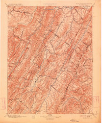
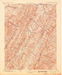
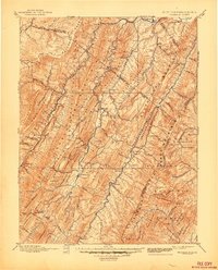
1896 Map of Franklin
USGS Topo · Published 1907About this map
The South Branch Potomac River and its multiple forks carve through the complex mountain ridges of Pendleton County during the late nineteenth century. This reconnaissance survey, conducted between 1884 and 1895, reveals a landscape defined by isolated gaps and river crossings, where small settlements like Franklin and Petersburg served as the primary nodes of commerce. The map documents numerous family-named landmarks and historical sites, including Fort Seybert and the community at Mouth of Seneca near the base of Spruce Mountain. Industrial activity of the era is evident in the placement of Harper Mill and Days Mills, situated along the watercourses that provided the power for local milling. Regional travel patterns are preserved through the identification of passes such as Mill Gap and Moyer Gap, which provided essential transit through the high terrain of Shenandoah Mountain and the Alleghany Front.
Find a feature on this map
109 named features on this map. Tap any name to fly to it.
Don’t see what you’re looking for? This feature index may not catch every label — zoom into the map to look around manually.
Map Details
Editions of this 1896 Franklin Map
4 editions found
Other maps of this area

1886 · St. George
USGS Topo · 1:125,000

1889 · Beverly
USGS Topo · 1:125,000

1891 · St. George
USGS Topo · 1:125,000

1891 · Romney
USGS Topo · 1:125,000

1892 · Beverly
USGS Topo · 1:125,000

1892 · Franklin
USGS Topo · 1:125,000

1892 · Woodstock
USGS Topo · 1:125,000

1892 · Harrisonburg
USGS Topo · 1:125,000

1894 · Staunton
USGS Topo · 1:125,000

1895 · Piedmont
USGS Topo · 1:125,000