1889 Map of Beverly
USGS Topo · Published 1889About this map
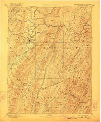
The town of Beverly serves as a focal point in this late nineteenth-century study of the high mountain gaps and river valleys of Randolph and Pocahontas counties. Settlement follows the major watercourses, with significant hubs like Huttonsville and Valley Bend appearing along the Tygart Valley River, while smaller outposts such as Traveller's Repose and Osceola are established in more isolated upland reaches. One of the most striking details is the Boundary Line In Dispute running between the Randolph and Pocahontas county lines, reflecting the surveying challenges of the era.
Find a feature on this map
127 named features on this map. Tap any name to fly to it.
Don’t see what you’re looking for? This feature index may not catch every label — zoom into the map to look around manually.
Map Details
Editions of this 1889 Beverly Map
This is the sole edition of this map. No revisions or reprints were ever made.