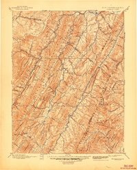
1892 Map of Franklin
USGS Topo · Published 1892About this map
Franklin and the surrounding Potomac highlands appear here during the late nineteenth century, defined by a landscape of parallel ridges and deep river valleys. The North Fork Potomac River and South Fork Potomac River serve as the primary corridors for settlement and travel, connecting communities like Upper Tract and Fort Seybert. The surveying by W.T. Griswold captures the intricate topography of Spruce Mountain and the Alleghany Front, revealing a region where early industry such as Harper Mill and isolated crossroads like Kline Cross Roads anchored local life.
Find a feature on this map
104 named features on this map. Tap any name to fly to it.
Don’t see what you’re looking for? This feature index may not catch every label — zoom into the map to look around manually.
Map Details
Editions of this 1892 Franklin Map
This is the sole edition of this map. No revisions or reprints were ever made.
Historical Maps of Petersburg Through Time
5 maps found