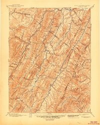
1896 Map of Franklin
USGS Topo · Published 1944About this map
The South Branch Potomac River and its parallel forks dominate this late 19th-century landscape, carving deep valleys between the high ridges of the Allegany Front and North Fork Mountain. The settlement pattern follows these narrow river corridors, where communities like Franklin and Petersburg served as vital hubs for the surrounding mountain hollows. The presence of Harper Mill and Days Mills suggests a local economy deeply tied to water power and timber in these well-watered drainages.
Find a feature on this map
109 named features on this map. Tap any name to fly to it.
Don’t see what you’re looking for? This feature index may not catch every label — zoom into the map to look around manually.
Map Details
Editions of this 1896 Franklin Map
4 editions found

Other maps of this area

1886 · St. George
USGS Topo · 1:125,000

1889 · Beverly
USGS Topo · 1:125,000

1891 · St. George
USGS Topo · 1:125,000

1891 · Romney
USGS Topo · 1:125,000

1892 · Beverly
USGS Topo · 1:125,000

1892 · Franklin
USGS Topo · 1:125,000

1892 · Woodstock
USGS Topo · 1:125,000

1892 · Harrisonburg
USGS Topo · 1:125,000

1894 · Staunton
USGS Topo · 1:125,000

1895 · Piedmont
USGS Topo · 1:125,000