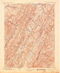
1896 Map of Franklin
USGS Topo · Published 1927About this map
High peaks and deep river gaps define the landscape of Franklin and the surrounding Potomac Highlands during this late nineteenth-century survey. The terrain is dominated by the Alleghany Front and the massive spine of Spruce Mountain, which together funnel settlement into the narrow valleys of the North Fork Potomac River and South Fork Potomac River. These waterways served as the primary corridors for early commerce and travel, connecting small mountain hamlets like Upper Tract, Fort Seybert, and Riverton.
Find a feature on this map
97 named features on this map. Tap any name to fly to it.
Don’t see what you’re looking for? This feature index may not catch every label — zoom into the map to look around manually.
Map Details
Editions of this 1896 Franklin Map
4 editions found

Other maps of this area

1886 · St. George
USGS Topo · 1:125,000

1889 · Beverly
USGS Topo · 1:125,000

1891 · St. George
USGS Topo · 1:125,000

1891 · Romney
USGS Topo · 1:125,000

1892 · Beverly
USGS Topo · 1:125,000

1892 · Franklin
USGS Topo · 1:125,000

1892 · Woodstock
USGS Topo · 1:125,000

1892 · Harrisonburg
USGS Topo · 1:125,000

1894 · Staunton
USGS Topo · 1:125,000

1895 · Piedmont
USGS Topo · 1:125,000