1900-1909 Maps of Odell, West Virginia
Explore 4 historic maps of Odell from 1900-1909. These maps offer a rare glimpse into what life looked like during the 1900s — showing old roads, neighborhoods, homes, and landmarks that have changed or disappeared over time.
Whether you're researching your family's past, planning a metal detecting trip, or studying how Odell's landscape evolved across the 1900s, these high-resolution maps are a powerful tool for exploring the history of this region.
- Focus on a specific era: All maps on this page are from the 1900s, giving you a focused view of this time period.
- See what’s changed: Compare century-old streets, trails, and buildings to today's modern landscape using overlays and satellite layers.
- Research with precision: Use these maps for genealogy, historical research, land use analysis, or educational projects.
- View, download, or print: Maps are fully viewable online in high resolution, and can be downloaded or printed for your own records.
Start exploring Odell's history through authentic maps from the 1900s. This is your window into the past.
Odell, WV maps
(4)- 1900 Map of Kanawha Falls
 1900 Kanawha Falls1900 Print · USGSThe Kanawha and Elk rivers converge here at the turn of the century as the coal and rail industries were rapidly transforming the West Virginia landscape. Genealogists and historians can trace riverside settlements like Montgomery and Coalburg or follow the paths of the Chesapeake and Ohio RR and early river navigation at Lock 2.
 - 1901 Map of Kanawha Falls
 1901 Kanawha Falls1901 Print · USGSWest Virginia's coal and rail heartland is captured here at the end of the nineteenth century, as river navigation and railroads transformed the Kanawha Valley. Genealogists and historians can trace the early footprints of Montgomery, find family sites near Kanawha Falls, and locate landmarks like Hawks Nest or Powellton.3 unique versions available
 - 1907 Map of Clendenin, 1962 Print
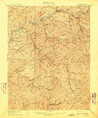
 1907 Clendenin1962 Print · USGSThe Elk River valley and its steep ridge-and-hollow terrain are captured here in the early 1900s as railroads expanded into the coalfields. Trace old river crossings at Jarretts Ford or locate remote hillside settlements like Putney, Quick, and Kendalia.2 unique versions available
 - 1909 Map of Clendenin
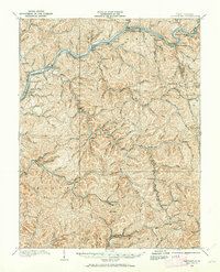
 1909 Clendenin1909 Print · USGSKanawha County’s rugged river corridors and rail-linked mining towns are captured here in the first decade of the twentieth century. Genealogists and historians can trace family locations near Jarretts Ford, Dry Ridge School, and the remote settlement of Blakeley.5 unique versions available
End of results
Showing maps 1-4 of 4
Top cities near Odell
- Charleston historical maps
- Montgomery historical maps
- Marmet historical maps
- Chesapeake historical maps
- Rand historical maps
- Belle historical maps
See more
Frequently asked questions
- What are the different types of historical maps available for Odell?
- What is the oldest map of Odell?
- Where can I purchase historical maps of Odell for my home or office?
- Where can I download high-res historical maps of Odell?
- Are there historical topographic maps available for Odell?
- Is there historical aerial imagery available for Odell?
- Where are historical maps of Odell sourced from?