1910s Maps of Apple Grove, West Virginia
Explore 4 historic maps of Apple Grove from the 1910s. These maps offer a rare glimpse into what life looked like during the 1910s — showing old roads, neighborhoods, homes, and landmarks that have changed or disappeared over time.
Whether you're researching your family's past, planning a metal detecting trip, or studying how Apple Grove's landscape evolved across the 1910s, these high-resolution maps are a powerful tool for exploring the history of this region.
- Focus on a specific era: All maps on this page are from the 1910s, giving you a focused view of this time period.
- See what’s changed: Compare century-old streets, trails, and buildings to today's modern landscape using overlays and satellite layers.
- Research with precision: Use these maps for genealogy, historical research, land use analysis, or educational projects.
- View, download, or print: Maps are fully viewable online in high resolution, and can be downloaded or printed for your own records.
Start exploring Apple Grove's history through authentic maps from the 1910s. This is your window into the past.
Apple Grove, WV maps
(4)- 1910 Map of Iaeger
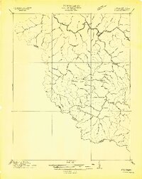 1910 Iaeger1910 Print · USGSMcDowell County's steep coal country is documented here in the early twentieth century as the railroad transformed the mountain landscape. Genealogists can trace family names and early homesteads near Iaeger, Avondale PO, and Paynesville along the Norfolk and Western RR.
 - 1912 Map of Iaeger
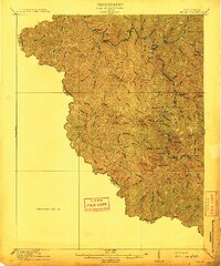 1912 Iaeger1912 Print · USGSMcDowell County's rugged Tug Fork valley is documented here in the early twentieth century, showing a landscape defined by rail and remote hollows. Genealogists and historians can trace the foundations of Iaeger, find the locations of Avondale PO and Bradshaw PO, and follow the Norfolk and Western tracks.
 - 1914 Map of Iaeger
 1914 Iaeger1914 Print · USGSCovers Apple Grove, including Raysal, Iaeger, and other nearby areas
 - 1916 Map of Iaeger
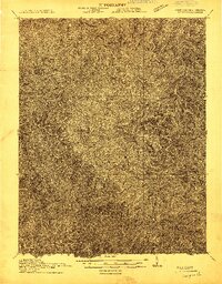
 1916 Iaeger1916 Print · USGSThe borderlands of West Virginia and Virginia are captured here in the early twentieth century, showing the coal-and-rail landscape of the Tug Fork. Genealogists and local historians can trace small community hubs like Avondale PO, Stacy PO, and family-named landmarks like Joshua Day School.
End of results
Showing maps 1-4 of 4
Top cities near Apple Grove
- Welch historical maps
- War historical maps
- Raysal historical maps
- Davy historical maps
- Gilbert historical maps
- Justice historical maps
See more
Frequently asked questions
- What are the different types of historical maps available for Apple Grove?
- What is the oldest map of Apple Grove?
- Where can I purchase historical maps of Apple Grove for my home or office?
- Where can I download high-res historical maps of Apple Grove?
- Are there historical topographic maps available for Apple Grove?
- Is there historical aerial imagery available for Apple Grove?
- Where are historical maps of Apple Grove sourced from?