2000s (21st Century) Maps of Mercer County, West Virginia
Explore 16 historic maps of Mercer County from the 2000s (21st Century). These maps offer a rare glimpse into what life looked like during the 2000s — showing old roads, neighborhoods, homes, and landmarks that have changed or disappeared over time.
Whether you're researching your family's past, planning a metal detecting trip, or studying how Mercer County's landscape evolved across the 2000s, these high-resolution maps are a powerful tool for exploring the history of this region.
- Focus on a specific era: All maps on this page are from the 2000s, giving you a focused view of this time period.
- See what’s changed: Compare century-old streets, trails, and buildings to today's modern landscape using overlays and satellite layers.
- Research with precision: Use these maps for genealogy, historical research, land use analysis, or educational projects.
- View, download, or print: Maps are fully viewable online in high resolution, and can be downloaded or printed for your own records.
Start exploring Mercer County's history through authentic maps from the 2000s. This is your window into the past.
Mercer County, WV maps
(16)- 2001 Map of Bramwell, 2003 Print
 2001 Bramwell2003 Print · USGSThe West Virginia and Virginia borderlands come into focus at the turn of the millennium, revealing a landscape shaped by the coal industry and the winding Bluestone River. Genealogists can trace family names at Pocahontas Cem or find old community centers like Abbs Valley Sch and Mt Sinai Ch.
 - 2022 Map of Bastian, 2022 Print
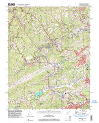
 2022 Bastian2022 Print · USGSBland and Tazewell counties in the early 2020s are defined by the intersection of mountain ridges and small valley settlements. Researchers can trace the path of the Appalachian National Scenic Trail and locate local landmarks like Bluefield University and Rose Hill Cem.
 - 2022 Map of Narrows, 2022 Print
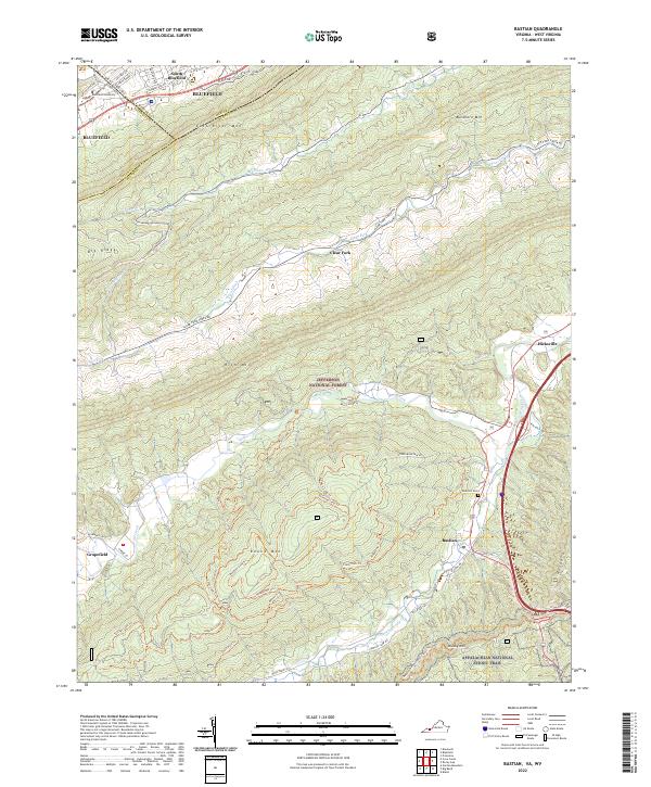
 2022 Narrows2022 Print · USGSGiles County, Virginia, is shown in the early 2020s as the New River cuts between massive ridgelines. Genealogists and hikers can trace the Appalachian National Scenic Trail past remote family plots like Woolwine Cem and Fletcher's Cem.
 - 2023 Map of Pipestem, 2023 Print
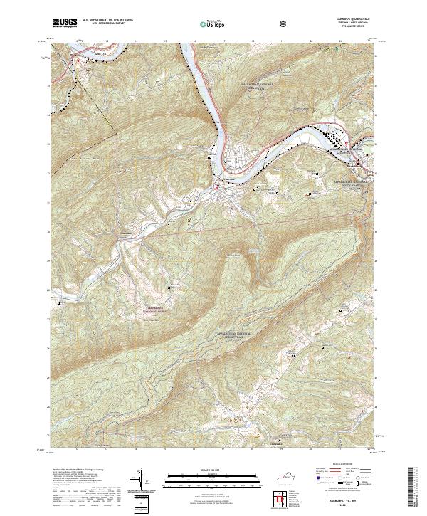
 2023 Pipestem2023 Print · USGSSummers and Mercer counties are captured here in the early twenty-first century, centered on the dramatic bends of the New River. Family historians can locate family plots at Rockymount Church Cem and Snider Cem or trace the old river-crossing at Haines Ferry.
 - 2023 Map of Lerona, 2023 Print
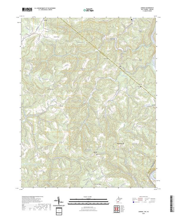 2023 Lerona2023 Print · USGSThe West Virginia uplands of Mercer County come alive in this detailed look at rural settlements like Lerona and Elgood. Researchers can trace family history through sites like White Cem and Browns Chapel Cem while orienting by landmarks like Bent Mountain.
 - 2023 Map of Peterstown, 2023 Print
 2023 Peterstown2023 Print · USGSThe West Virginia-Virginia borderlands near Peterstown are mapped here in the early twenty-first century, showing the enduring rural character of the New River valley. Genealogists can trace family heritage through sites like Shumate Cem and Shanklins Ferry.
 - 2023 Map of Oakvale, 2023 Print
 2023 Oakvale2023 Print · USGSThe East River valley at the West Virginia-Virginia border shows a landscape where mountain ridges dictate the flow of travel and settlement. Genealogists can trace family names through the Millirons Family Cem, First Ford, and the old rail-side community of Oakvale.
 - 2023 Map of Bluefield, 2023 Print
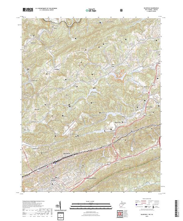 2023 Bluefield2023 Print · USGSBluefield and the surrounding ridgelines of the West Virginia-Virginia border are captured here in the early twenty-first century. Genealogists and historians can trace numerous family burial grounds like Neal Cem and Tuggle Cem or locate the historic campus of Bluefield State College.
 - 2023 Map of Princeton, 2023 Print
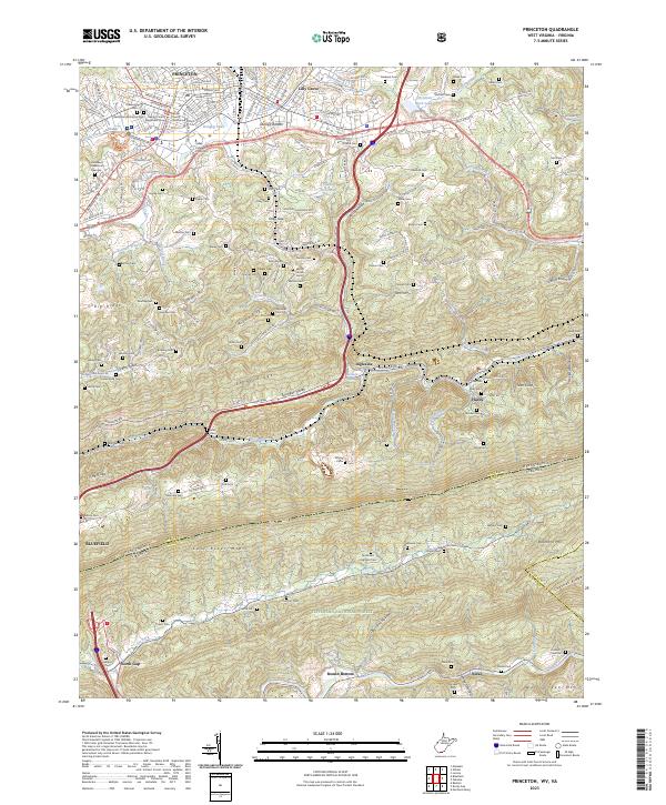 2023 Princeton2023 Print · USGSModern Princeton and the West Virginia-Virginia borderlands are documented here at a moment when urban growth meets the protected slopes of East River Mtn. Genealogists and local historians can trace family locations through numerous sites like Shumate Cem, Stumpy Bottom, and the Mercer County Courthouse.
 - 2023 Map of Bramwell, 2023 Print
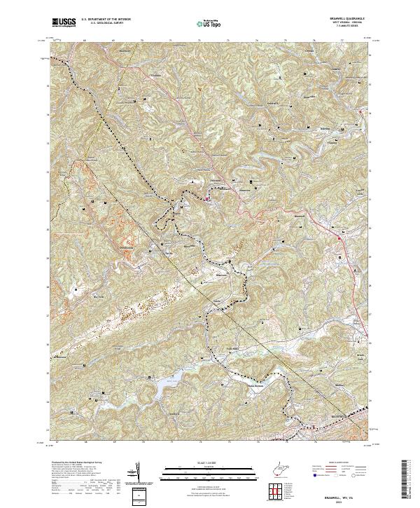 2023 Bramwell2023 Print · USGSThe coal country of the West Virginia and Virginia border comes into sharp focus in this detailed modern survey. Genealogists and local historians can trace family burial sites and old mining communities from Bramwell and Pocahontas to the Bryant Memorial Cem and Pinnacle Rock.
 - 2023 Map of Odd, 2023 Print
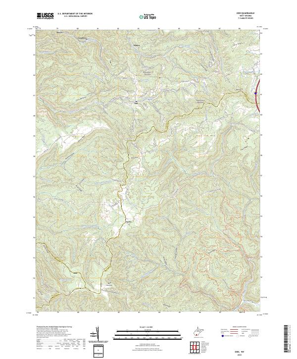 2023 Odd2023 Print · USGSRaleigh County and its neighbors at the turn of the twenty-first century reveal a landscape of mountain ridges and remote hollows. Genealogists and hikers can trace early routes like Old Egeria Rd and locate family-named landmarks like Rich Knob or Willibet.
 - 2023 Map of Crumpler, 2023 Print
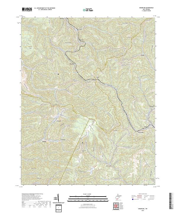 2023 Crumpler2023 Print · USGSThe West Virginia coalfields near the McDowell and Mercer county line are documented here in recent detail. Genealogists and local researchers can trace the roads connecting settlements like Crumpler, Ashland, and McComas, or locate family sites like Bailey Cem.
 - 2023 Map of Matoaka, 2023 Print
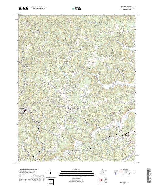 2023 Matoaka2023 Print · USGSMercer County's Appalachian landscape is documented here in the early twenty-first century, revealing a dense network of valley settlements and ridge-top cemeteries. Genealogists can trace family sites at Saint Peters Lutheran Cem and Mount Olive Cem or locate community centers like Matoaka and Lashmeet.
 - 2023 Map of Athens, 2023 Print
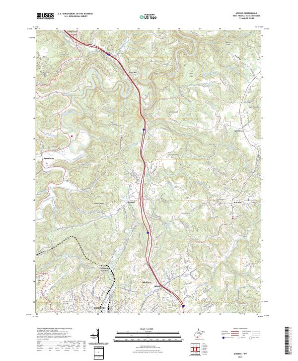 2023 Athens2023 Print · USGSMercer County's highland terrain and river valleys are captured here in the early 2020s, showing the settled landscape of the Appalachian Plateau. Researchers can trace local landmarks from Concord University to the historic Mercer Healing Springs and Eads Mill.
 - 2023 Map of Rhodell, 2023 Print
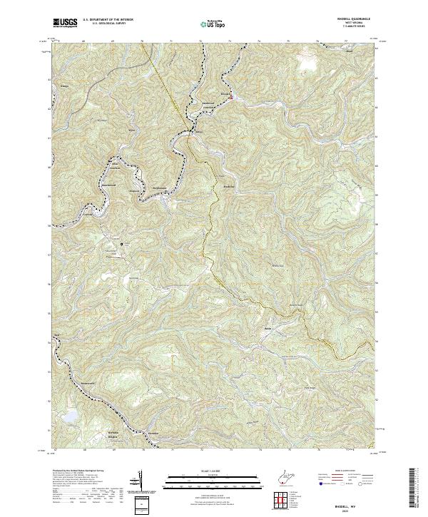 2023 Rhodell2023 Print · USGSThe West Virginia coalfields near the Raleigh and Wyoming county line come into focus in this contemporary study. Researchers can trace family history through Milam Cem or locate old rail-and-river towns like Amigo, Stephenson, and Herndon.
 - 2023 Map of Flat Top, 2023 Print
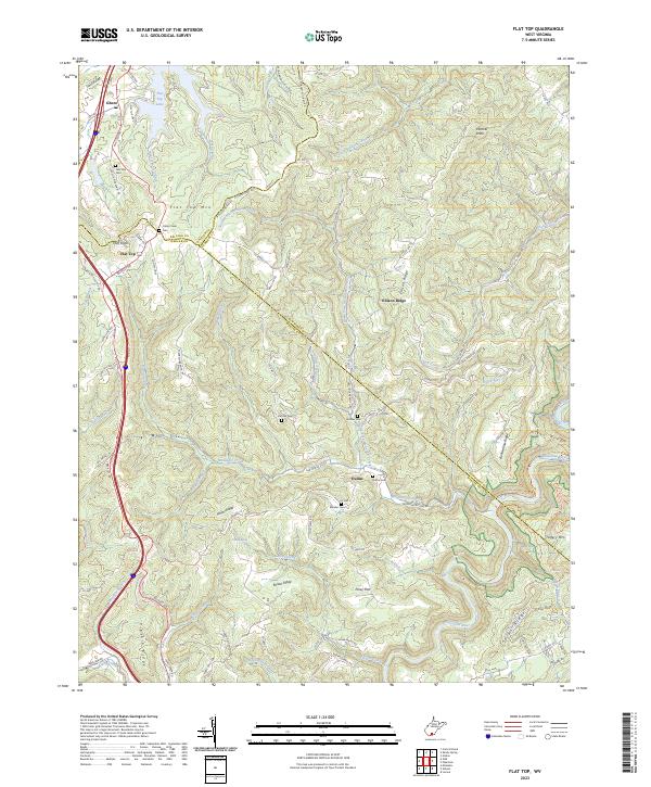 2023 Flat Top2023 Print · USGSThe high ridge country of Mercer and Raleigh counties comes into focus in this recent study of southern West Virginia. Genealogists and hikers can trace family sites like Tom Lilly Cem and explore the protected Bluestone Wild and Scenic River.
End of results
Showing maps 1-16 of 16
Top cities of Mercer County
- Bluefield historical maps
- Princeton historical maps
- Athens historical maps
- Brush Fork historical maps
- Lashmeet historical maps
- Bramwell historical maps
See more
Frequently asked questions
- What are the different types of historical maps available for Mercer County?
- What is the oldest map of Mercer County?
- Where can I purchase historical maps of Mercer County for my home or office?
- Where can I download high-res historical maps of Mercer County?
- Are there historical topographic maps available for Mercer County?
- Is there historical aerial imagery available for Mercer County?
- Where are historical maps of Mercer County sourced from?