1910s Maps of Mercer County, West Virginia
Explore 10 historic maps of Mercer County from the 1910s. These maps offer a rare glimpse into what life looked like during the 1910s — showing old roads, neighborhoods, homes, and landmarks that have changed or disappeared over time.
Whether you're researching your family's past, planning a metal detecting trip, or studying how Mercer County's landscape evolved across the 1910s, these high-resolution maps are a powerful tool for exploring the history of this region.
- Focus on a specific era: All maps on this page are from the 1910s, giving you a focused view of this time period.
- See what’s changed: Compare century-old streets, trails, and buildings to today's modern landscape using overlays and satellite layers.
- Research with precision: Use these maps for genealogy, historical research, land use analysis, or educational projects.
- View, download, or print: Maps are fully viewable online in high resolution, and can be downloaded or printed for your own records.
Start exploring Mercer County's history through authentic maps from the 1910s. This is your window into the past.
Mercer County, WV maps
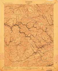
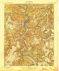
(10)- 1911 Map of Flattop
 1911 Flattop1911 Print · USGSSouthern West Virginia’s coal and timber country comes into focus just as the railroads transformed these ridges and hollows. Genealogists can trace dozens of rural schoolhouses and family-named landmarks like Huff Knob, Egeria, and the VIRGINIAN RY corridor.
 - 1911 Map of Pocahontas Special
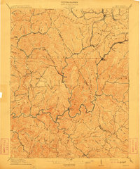
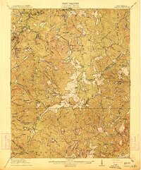
 1911 Pocahontas Special1911 Print · USGSThe West Virginia coalfields are in full industrial bloom in this early century survey, showing the rail-dependent towns along the Norfolk & Western RR. Genealogists can trace family locations in mining hubs like Keystone, Goodwill, and Bearwallow Worth PO.
 - 1912 Map of Mullens
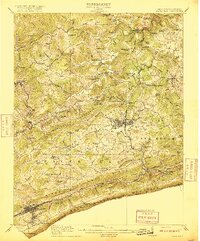
 1912 Mullens1912 Print · USGSThe Raleigh and Wyoming county lines meet in this 1910 study of the West Virginia coalfields during a period of rapid industrial growth. Genealogists and historians can trace the early path of the Virginian RR and locate vanished company towns like Stotesbury, Glen White, and Hotchkiss.2 unique versions available
 - 1912 Map of Big Bend, 1964 Print
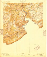
 1912 Big Bend1964 Print · USGSSummers County at the height of the steam era reveals a landscape shaped by the meeting of the Greenbrier and New Rivers. You can trace the path of the Chesapeake and Ohio RR through the Big Bend Tunnel or locate long-lost rural schools like Rock Bottom School and Spicklick School.
 - 1913 Map of Peterstown
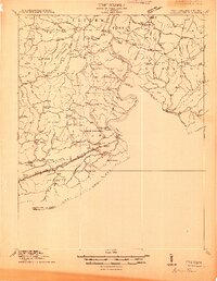 1913 Peterstown1913 Print · USGSPeterstown and the New River valley are captured in the early twentieth century as the railroad transformed these mountain borderlands. Genealogists and historians can trace dozens of rural schoolhouses and stops like Willowton PO, Shanklins Ferry, and Oakvale.
 - 1913 Map of Bluefield
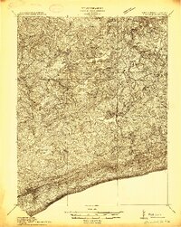 1913 Bluefield1913 Print · USGSMercer County and the Virginia borderlands are captured here just before the Great War, showing a landscape of mountain ridges and river valleys. Genealogists and historians can locate dozens of early rural schoolhouses like Sand Gap School and Grecian Bend School, alongside the developing streets of Princeton and South Bluefield.
 - 1914 Map of Big Bend
 1914 Big Bend1914 Print · USGSIn the early twentieth century, the New River valley was a bustling corridor defined by its railroads and mountain settlements. Genealogists can trace family footprints at Packs Ferry PO, the Big Bend Tunnel, and numerous rural sites like Indian Mills.4 unique versions available
 - 1914 Map of Flattop
 1914 Flattop1914 Print · USGSSouthern West Virginia in the early twentieth century was a landscape of steep coal hollows and high-altitude ridge farming. Genealogists can locate dozens of country schools like Chestnut Ridge School and Phillips School alongside the emerging rail lines at Winding Gulf.2 unique versions available
 - 1916 Map of Bluefield
 1916 Bluefield1916 Print · USGSMercer County and the Virginia border come alive in this survey of coal-country rail and mountain ridge communities. Genealogists can trace family roots through dozens of named schools like Sand Gap School and early post offices such as Hardy PO.
 - 1916 Map of Peterstown
 1916 Peterstown1916 Print · USGSMonroe and Mercer Counties are seen here in the decade before the First World War, defined by steep ridges and the critical rail corridors of the New River valley. Genealogists can locate dozens of country schools and remote landmarks like Mauvern Saltworks, Goodwin Chapel, and Shanklins Ferry.2 unique versions available
End of results
Showing maps 1-10 of 10
Top cities of Mercer County
- Bluefield historical maps
- Princeton historical maps
- Athens historical maps
- Brush Fork historical maps
- Lashmeet historical maps
- Bramwell historical maps
See more
Frequently asked questions
- What are the different types of historical maps available for Mercer County?
- What is the oldest map of Mercer County?
- Where can I purchase historical maps of Mercer County for my home or office?
- Where can I download high-res historical maps of Mercer County?
- Are there historical topographic maps available for Mercer County?
- Is there historical aerial imagery available for Mercer County?
- Where are historical maps of Mercer County sourced from?