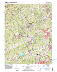
2001 Map of Bramwell
USGS Topo · Published 2003About this map
Bramwell and the surrounding coal country of the Appalachian Plateau are depicted here at the start of the twenty-first century, showing a landscape defined by industrial history and topographical extremes. The winding course of the Bluestone River dictates the placement of settlements like Coopers, Simmons, and Freeman, while the Norfolk and Western railway traces the valleys to serve the region's legacy of extraction. Significant landmarks such as the Pocahontas Mine and the sprawling Pocahontas Cem reflect the deep-rooted mining heritage of this borderland area.
Find a feature on this map
145 named features on this map. Tap any name to fly to it.
Don’t see what you’re looking for? This feature index may not catch every label — zoom into the map to look around manually.
Map Details
Editions of this 2001 Bramwell Map
This is the sole edition of this map. No revisions or reprints were ever made.
Other maps of this area

1887 · Pocahontas
USGS Topo · 1:125,000

1891 · Pocahontas
USGS Topo · 1:125,000

1894 · Pocahontas
USGS Topo · 1:125,000

1895 · Pocahontas
USGS Topo · 1:125,000

1909 · Pocahontas Special
USGS Topo · 1:48,000

1911 · Pocahontas Special
USGS Topo · 1:62,500

1913 · Bluefield
USGS Topo · 1:48,000

1916 · Bluefield
USGS Topo · 1:62,500

1924 · Bramwell
USGS Topo · 1:62,500

1924 · Bluefield
USGS Topo · 1:62,500