1990s Maps of Persinger Ford, West Virginia
Explore 1 historic maps of Persinger Ford from the 1990s. These maps offer a rare glimpse into what life looked like during the 1990s — showing old roads, neighborhoods, homes, and landmarks that have changed or disappeared over time.
Whether you're researching your family's past, planning a metal detecting trip, or studying how Persinger Ford's landscape evolved across the 1990s, these high-resolution maps are a powerful tool for exploring the history of this region.
- Focus on a specific era: All maps on this page are from the 1990s, giving you a focused view of this time period.
- See what’s changed: Compare century-old streets, trails, and buildings to today's modern landscape using overlays and satellite layers.
- Research with precision: Use these maps for genealogy, historical research, land use analysis, or educational projects.
- View, download, or print: Maps are fully viewable online in high resolution, and can be downloaded or printed for your own records.
Start exploring Persinger Ford's history through authentic maps from the 1990s. This is your window into the past.
Persinger Ford, WV maps
(1)- 1996 Map of Summersville, 2003 Print
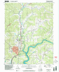 1996 Summersville2003 Print · USGSSummersville and the Gauley River valley are captured in the late nineties as a mix of growing town centers and rural mountain communities. Trace family roots and local industry through the Glade Creek Sch, small mines, and numerous rural churches like St Martins Ch.
End of results
Showing maps 1-1 of 1
Top cities near Persinger Ford
- Summersville historical maps
- Richwood historical maps
- Craigsville historical maps
- Cowen historical maps
- Groves Ford historical maps
Frequently asked questions
- What are the different types of historical maps available for Persinger Ford?
- What is the oldest map of Persinger Ford?
- Where can I purchase historical maps of Persinger Ford for my home or office?
- Where can I download high-res historical maps of Persinger Ford?
- Are there historical topographic maps available for Persinger Ford?
- Is there historical aerial imagery available for Persinger Ford?
- Where are historical maps of Persinger Ford sourced from?