1960s Maps of Summersville, West Virginia
Explore 3 historic maps of Summersville from the 1960s. These maps offer a rare glimpse into what life looked like during the 1960s — showing old roads, neighborhoods, homes, and landmarks that have changed or disappeared over time.
Whether you're researching your family's past, planning a metal detecting trip, or studying how Summersville's landscape evolved across the 1960s, these high-resolution maps are a powerful tool for exploring the history of this region.
- Focus on a specific era: All maps on this page are from the 1960s, giving you a focused view of this time period.
- See what’s changed: Compare century-old streets, trails, and buildings to today's modern landscape using overlays and satellite layers.
- Research with precision: Use these maps for genealogy, historical research, land use analysis, or educational projects.
- View, download, or print: Maps are fully viewable online in high resolution, and can be downloaded or printed for your own records.
Start exploring Summersville's history through authentic maps from the 1960s. This is your window into the past.
Summersville, WV maps
(3)- 1961 Map of Charleston
 1961 Charleston1961 Print · USGSWest Virginia's capital region and the highlands to the east are shown in detail during the early sixties. Genealogists and historians can trace rail networks like the Baltimore and Ohio RR and find early state parks such as Watoga State Park.
 - 1967 Map of Summersville, 1968 Print
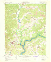 1967 Summersville1968 Print · USGSNicholas County at the peak of its coal-and-gas era shows a landscape undergoing significant change as Summersville Lake fills the Gauley valley. Genealogy researchers can trace family landmarks like Lonetree Mtn, Beulah Ch, and the Glade Creek Sch.2 unique versions available
 - 1969 Map of Mount Nebo, 1973 Print
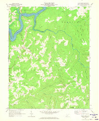 1969 Mount Nebo1973 Print · USGSNicholas County's rural highlands are captured here in the late sixties as recreation grew around Summersville Lake. Genealogists can trace family names and sites from Mount Nebo to quiet landmarks like Dixon Chapel, Runa, and Spruce Grove Cem & Ch.2 unique versions available
End of results
Showing maps 1-3 of 3
Top cities near Summersville
- Craigsville historical maps
- Quinwood historical maps
- Persinger Ford historical maps
- Groves Ford historical maps
Top neighborhoods of Summersville
- Holly Hills Estates historical maps
- Pine Trailer Park historical maps
- Bright Mountain Estates historical maps
- Tara Estates historical maps
Frequently asked questions
- What are the different types of historical maps available for Summersville?
- What is the oldest map of Summersville?
- Where can I purchase historical maps of Summersville for my home or office?
- Where can I download high-res historical maps of Summersville?
- Are there historical topographic maps available for Summersville?
- Is there historical aerial imagery available for Summersville?
- Where are historical maps of Summersville sourced from?