1900s (20th Century) Maps of Brandywine, West Virginia
Explore 9 historic maps of Brandywine from the 1900s (20th Century). These maps offer a rare glimpse into what life looked like during the 1900s — showing old roads, neighborhoods, homes, and landmarks that have changed or disappeared over time.
Whether you're researching your family's past, planning a metal detecting trip, or studying how Brandywine's landscape evolved across the 1900s, these high-resolution maps are a powerful tool for exploring the history of this region.
- Focus on a specific era: All maps on this page are from the 1900s, giving you a focused view of this time period.
- See what’s changed: Compare century-old streets, trails, and buildings to today's modern landscape using overlays and satellite layers.
- Research with precision: Use these maps for genealogy, historical research, land use analysis, or educational projects.
- View, download, or print: Maps are fully viewable online in high resolution, and can be downloaded or printed for your own records.
Start exploring Brandywine's history through authentic maps from the 1900s. This is your window into the past.
Brandywine, WV maps
(9)- 1922 Map of Fort Seybert
 1922 Fort Seybert1922 Print · USGSPendleton County's South Fork Valley is captured in the early 1920s, showing a landscape of remote mountain homesteads and small valley hamlets. Genealogists can locate family landmarks like Locust Grove School, New Bethel Church, and the high peaks of Shenandoah Mountain.2 unique versions available
 - 1924 Map of Fort Seybert
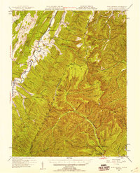
 1924 Fort Seybert1924 Print · USGSIn the early 1920s, the Pendleton County highlands were defined by remote mountain gaps and close-knit valley settlements. Genealogists can locate family-named landmarks and rural hubs like Fort Seybert, Brandywine, and the Cedar Grove School.3 unique versions available
 - 1947 Map of Fort Seybert, 1958 Print
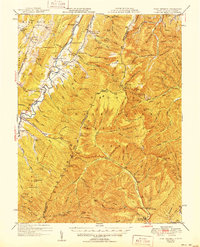
 1947 Fort Seybert1958 Print · USGSThe South Fork Potomac River highlands are captured here in the late 1940s, showing a landscape defined by isolated farmsteads and rural mountain schools. Researchers can trace family-named landmarks and community centers like Fort Seybert, Pleasant Grove Ch, and the Dale Hill Sch.2 unique versions available
 - 1949 Map of Charlottesville
 1949 Charlottesville1949 Print · USGSThe Shenandoah Valley and Blue Ridge appear in the late 1940s as a thriving corridor of rail and river commerce. Researchers can trace the mid-century footprints of Harrisonburg, Staunton, and Culpeper alongside the historic routes of the Southern Railway.2 unique versions available
 - 1951 Map of Fort Seybert
 1951 Fort Seybert1951 Print · USGSThe South Fork Potomac River valley in the early 1950s reveals a landscape of isolated mountain hollows and tight-knit highland settlements. Genealogists can locate family landmarks such as Fort Seybert, New Bethlehem Ch, and the Cedar Grove Sch.2 unique versions available
 - 1956 Map of Charlottesville, 1966 Print
 1956 Charlottesville1966 Print · USGSThe Shenandoah Valley and Blue Ridge are captured in detail during the mid-1960s as the modern interstate system began to emerge. Genealogists and historians can trace rail-connected hubs like Waynesboro or follow the river paths of the Rapidan River and Rivanna River.4 unique versions available
 - 1969 Map of Brandywine, 1970 Print
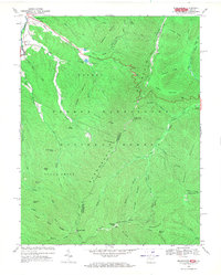 1969 Brandywine1970 Print · USGSThe West Virginia and Virginia border comes alive in the late sixties as the mountain ridges of the George Washington National Forest meet the Brandywine valley. Genealogists and hikers can trace Cedar Grove Ch, the Maple Spring Trail, and high points like High Knob.2 unique versions available
 - 1981 Map of Elkins, 1983 Print
 1981 Elkins1983 Print · USGSThe West Virginia mountains in the early eighties were a hub of rail-based industry and emerging conservation lands. Genealogists and historians can trace the paths of the Western Maryland RR through Elkins and locate small upland communities like Harpertown, Bowden, and Wymer.
 - 1999 Map of Brandywine, 2001 Print
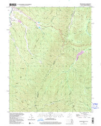 1999 Brandywine2001 Print · USGSThe West Virginia and Virginia borderlands meet along these high ridges as the new millennium approached. Researchers can trace family history at Pine Hill Cem or locate old landmarks like the Martin Luther Ch and High Knob Lookout Tower.
End of results
Showing maps 1-9 of 9
Top cities near Brandywine
Frequently asked questions
- What are the different types of historical maps available for Brandywine?
- What is the oldest map of Brandywine?
- Where can I purchase historical maps of Brandywine for my home or office?
- Where can I download high-res historical maps of Brandywine?
- Are there historical topographic maps available for Brandywine?
- Is there historical aerial imagery available for Brandywine?
- Where are historical maps of Brandywine sourced from?