1940s Maps of Brandywine, West Virginia
Explore 2 historic maps of Brandywine from the 1940s. These maps offer a rare glimpse into what life looked like during the 1940s — showing old roads, neighborhoods, homes, and landmarks that have changed or disappeared over time.
Whether you're researching your family's past, planning a metal detecting trip, or studying how Brandywine's landscape evolved across the 1940s, these high-resolution maps are a powerful tool for exploring the history of this region.
- Focus on a specific era: All maps on this page are from the 1940s, giving you a focused view of this time period.
- See what’s changed: Compare century-old streets, trails, and buildings to today's modern landscape using overlays and satellite layers.
- Research with precision: Use these maps for genealogy, historical research, land use analysis, or educational projects.
- View, download, or print: Maps are fully viewable online in high resolution, and can be downloaded or printed for your own records.
Start exploring Brandywine's history through authentic maps from the 1940s. This is your window into the past.
Brandywine, WV maps
(2)- 1947 Map of Fort Seybert, 1958 Print
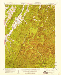 1947 Fort Seybert1958 Print · USGSThe South Fork Potomac River highlands are captured here in the late 1940s, showing a landscape defined by isolated farmsteads and rural mountain schools. Researchers can trace family-named landmarks and community centers like Fort Seybert, Pleasant Grove Ch, and the Dale Hill Sch.2 unique versions available
 - 1949 Map of Charlottesville
 1949 Charlottesville1949 Print · USGSThe Shenandoah Valley and Blue Ridge appear in the late 1940s as a thriving corridor of rail and river commerce. Researchers can trace the mid-century footprints of Harrisonburg, Staunton, and Culpeper alongside the historic routes of the Southern Railway.2 unique versions available
End of results
Showing maps 1-2 of 2
Top cities near Brandywine
Frequently asked questions
- What are the different types of historical maps available for Brandywine?
- What is the oldest map of Brandywine?
- Where can I purchase historical maps of Brandywine for my home or office?
- Where can I download high-res historical maps of Brandywine?
- Are there historical topographic maps available for Brandywine?
- Is there historical aerial imagery available for Brandywine?
- Where are historical maps of Brandywine sourced from?