1900s (20th Century) Maps of Kline, West Virginia
Explore 8 historic maps of Kline from the 1900s (20th Century). These maps offer a rare glimpse into what life looked like during the 1900s — showing old roads, neighborhoods, homes, and landmarks that have changed or disappeared over time.
Whether you're researching your family's past, planning a metal detecting trip, or studying how Kline's landscape evolved across the 1900s, these high-resolution maps are a powerful tool for exploring the history of this region.
- Focus on a specific era: All maps on this page are from the 1900s, giving you a focused view of this time period.
- See what’s changed: Compare century-old streets, trails, and buildings to today's modern landscape using overlays and satellite layers.
- Research with precision: Use these maps for genealogy, historical research, land use analysis, or educational projects.
- View, download, or print: Maps are fully viewable online in high resolution, and can be downloaded or printed for your own records.
Start exploring Kline's history through authentic maps from the 1900s. This is your window into the past.
Kline, WV maps
(8)- 1920 Map of Petersburg
 1920 Petersburg1920 Print · USGSThe West Virginia and Virginia borderlands were a network of tight-knit mountain communities just after the Great War. Genealogists can locate family-named sites like Schmuckers School and Sites Chapel or trace the early Smoke Hole Settlement.3 unique versions available
 - 1921 Map of Petersburg
 1921 Petersburg1921 Print · USGSEastern West Virginia at the start of the twenties shows a landscape of mountain hollows tied together by the Baltimore and Ohio at Petersburg. Genealogists can trace family names through landmarks like Hedrick Church, Crites School, and Ketterman.
 - 1922 Map of Petersburg
 1922 Petersburg1922 Print · USGSThe West Virginia highlands in the early 1920s are centered here on the river valley at Petersburg. Researchers can locate dozens of rural schools and mountain churches, including Royal Glen Mill, Hedrick Church, and Mountaindale School.2 unique versions available
 - 1949 Map of Charlottesville
 1949 Charlottesville1949 Print · USGSThe Shenandoah Valley and Blue Ridge appear in the late 1940s as a thriving corridor of rail and river commerce. Researchers can trace the mid-century footprints of Harrisonburg, Staunton, and Culpeper alongside the historic routes of the Southern Railway.2 unique versions available
 - 1956 Map of Charlottesville, 1966 Print
 1956 Charlottesville1966 Print · USGSThe Shenandoah Valley and Blue Ridge are captured in detail during the mid-1960s as the modern interstate system began to emerge. Genealogists and historians can trace rail-connected hubs like Waynesboro or follow the river paths of the Rapidan River and Rivanna River.4 unique versions available
 - 1969 Map of Mozer, 1972 Print
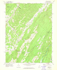 1969 Mozer1972 Print · USGSPendleton County's high ridges and river valleys are captured here in the late sixties as traditional mountain life met modern conservation boundaries. Genealogists can locate family landmarks like Mt Horeb Ch, the settlement of Mozer, and numerous cemeteries tucked away in Mill Run and Sweedlin Valley.2 unique versions available
 - 1981 Map of Elkins, 1983 Print
 1981 Elkins1983 Print · USGSThe West Virginia mountains in the early eighties were a hub of rail-based industry and emerging conservation lands. Genealogists and historians can trace the paths of the Western Maryland RR through Elkins and locate small upland communities like Harpertown, Bowden, and Wymer.
 - 1995 Map of Mozer, 1998 Print
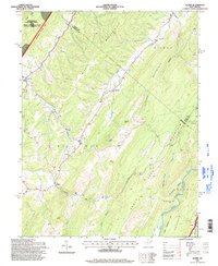 1995 Mozer1998 Print · USGSPendleton and Grant counties are captured in the mid-1990s, showing a landscape of high ridges and narrow valley settlements. Genealogists and hikers can trace the rural homes and mountain gaps near Mozer, Mt Horeb Ch, and the rugged peaks of Cave Mtn.
End of results
Showing maps 1-8 of 8
Top cities near Kline
Frequently asked questions
- What are the different types of historical maps available for Kline?
- What is the oldest map of Kline?
- Where can I purchase historical maps of Kline for my home or office?
- Where can I download high-res historical maps of Kline?
- Are there historical topographic maps available for Kline?
- Is there historical aerial imagery available for Kline?
- Where are historical maps of Kline sourced from?