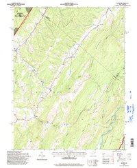
1995 Map of Mozer
USGS Topo · Published 1998About this map
Mozer, Kline, and Brushy Run serve as the primary nodes of settlement in this 1990s portrait of Pendleton and Grant counties. The terrain is defined by a series of parallel ridges including Middle Mountain, Spring Mountain, and Mountain Ridge, which funnel the local drainage toward the Potomac River and South Fork. These valleys support a network of rural homesteads and houses of worship such as South Mill Creek Ch, Trinity Ch, and Mt Horeb Ch, often located near the numerous named runs and hollows like Kessner Run and Wolfpen Hollow. Much of the western landscape is managed by the Monongahela National Forest, including the Spruce Knob-Seneca Rocks National Recreation Area, while the George Washington National Forest borders the South Fork Valley to the southeast.
Find a feature on this map
43 named features on this map. Tap any name to fly to it.
Don’t see what you’re looking for? This feature index may not catch every label — zoom into the map to look around manually.
Map Details
Editions of this 1995 Mozer Map
This is the sole edition of this map. No revisions or reprints were ever made.
Other maps of this area

1892 · Franklin
USGS Topo · 1:125,000

1896 · Franklin
USGS Topo · 1:125,000

1920 · Petersburg
USGS Topo · 1:48,000

1920 · Onego
USGS Topo · 1:62,500

1921 · Petersburg
USGS Topo · 1:48,000

1921 · Onego
USGS Topo · 1:48,000

1922 · Onego
USGS Topo · 1:62,500

1922 · Fort Seybert
USGS Topo · 1:48,000

1922 · Petersburg
USGS Topo · 1:62,500

1922 · Circleville
USGS Topo · 1:62,500