1910s Maps of Friendly View, West Virginia
Explore 2 historic maps of Friendly View from the 1910s. These maps offer a rare glimpse into what life looked like during the 1910s — showing old roads, neighborhoods, homes, and landmarks that have changed or disappeared over time.
Whether you're researching your family's past, planning a metal detecting trip, or studying how Friendly View's landscape evolved across the 1910s, these high-resolution maps are a powerful tool for exploring the history of this region.
- Focus on a specific era: All maps on this page are from the 1910s, giving you a focused view of this time period.
- See what’s changed: Compare century-old streets, trails, and buildings to today's modern landscape using overlays and satellite layers.
- Research with precision: Use these maps for genealogy, historical research, land use analysis, or educational projects.
- View, download, or print: Maps are fully viewable online in high resolution, and can be downloaded or printed for your own records.
Start exploring Friendly View's history through authentic maps from the 1910s. This is your window into the past.
Friendly View, WV maps
(2)- 1911 Map of Marshes
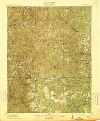
 1911 Marshes1911 Print · USGSRaleigh County and the surrounding highlands are shown just after the turn of the century, when mountain life centered on isolated creek hollows. Genealogists can trace family footprints through dozens of rural landmarks like Meadow Inn School, Matville P O, and Peachtree School.
 - 1914 Map of Eccles
 1914 Eccles1914 Print · USGSRaleigh County's mountain settlements and coal-country railways are captured here in the early twentieth century. Researchers can trace the heritage of rural communities through dozens of schoolhouses like White Rose School and local landmarks such as Meadow Inn or the Trap Hill Marshes PO.2 unique versions available
End of results
Showing maps 1-2 of 2
Top cities near Friendly View
- Oceana historical maps
- Sophia historical maps
- Kopperston historical maps
- Whitesville historical maps
- Powellton historical maps
- Sylvester historical maps
See more
Frequently asked questions
- What are the different types of historical maps available for Friendly View?
- What is the oldest map of Friendly View?
- Where can I purchase historical maps of Friendly View for my home or office?
- Where can I download high-res historical maps of Friendly View?
- Are there historical topographic maps available for Friendly View?
- Is there historical aerial imagery available for Friendly View?
- Where are historical maps of Friendly View sourced from?