1960s Maps of Beverly, West Virginia
Explore 2 historic maps of Beverly from the 1960s. These maps offer a rare glimpse into what life looked like during the 1960s — showing old roads, neighborhoods, homes, and landmarks that have changed or disappeared over time.
Whether you're researching your family's past, planning a metal detecting trip, or studying how Beverly's landscape evolved across the 1960s, these high-resolution maps are a powerful tool for exploring the history of this region.
- Focus on a specific era: All maps on this page are from the 1960s, giving you a focused view of this time period.
- See what’s changed: Compare century-old streets, trails, and buildings to today's modern landscape using overlays and satellite layers.
- Research with precision: Use these maps for genealogy, historical research, land use analysis, or educational projects.
- View, download, or print: Maps are fully viewable online in high resolution, and can be downloaded or printed for your own records.
Start exploring Beverly's history through authentic maps from the 1960s. This is your window into the past.
Beverly, WV maps
(2)- 1968 Map of Beverly West, 1971 Print
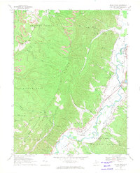 1968 Beverly West1971 Print · USGSThe Tygart Valley River valley in the late sixties reveals a landscape of railroad towns and mountain industry. Genealogists and historians can locate the Homestead Sch, Valley Bend Ch, and family landmarks like Wood Cem.3 unique versions available
 - 1969 Map of Beverly East, 1971 Print
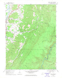 1969 Beverly East1971 Print · USGSThe Tygart Valley and the high ridges of the Monongahela National Forest are captured here in the late sixties. Genealogists and historians can trace the rural landscape of Beverly and Hazelwood, or locate remote points like Elk River Junction and Mt Vernon Ch.3 unique versions available
End of results
Showing maps 1-2 of 2
Top cities near Beverly
- Elkins historical maps
- Mill Creek historical maps
- Valley Bend historical maps
- East Dailey historical maps
- Junior historical maps
- Norton historical maps
See more
Top neighborhoods of Beverly
Frequently asked questions
- What are the different types of historical maps available for Beverly?
- What is the oldest map of Beverly?
- Where can I purchase historical maps of Beverly for my home or office?
- Where can I download high-res historical maps of Beverly?
- Are there historical topographic maps available for Beverly?
- Is there historical aerial imagery available for Beverly?
- Where are historical maps of Beverly sourced from?