1920s Maps of Harman, West Virginia
Explore 2 historic maps of Harman from the 1920s. These maps offer a rare glimpse into what life looked like during the 1920s — showing old roads, neighborhoods, homes, and landmarks that have changed or disappeared over time.
Whether you're researching your family's past, planning a metal detecting trip, or studying how Harman's landscape evolved across the 1920s, these high-resolution maps are a powerful tool for exploring the history of this region.
- Focus on a specific era: All maps on this page are from the 1920s, giving you a focused view of this time period.
- See what’s changed: Compare century-old streets, trails, and buildings to today's modern landscape using overlays and satellite layers.
- Research with precision: Use these maps for genealogy, historical research, land use analysis, or educational projects.
- View, download, or print: Maps are fully viewable online in high resolution, and can be downloaded or printed for your own records.
Start exploring Harman's history through authentic maps from the 1920s. This is your window into the past.
Harman, WV maps
(2)- 1922 Map of Horton
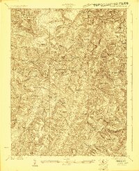 1922 Horton1922 Print · USGSThe West Virginia highlands in the early twenties were a landscape of mountain timber towns and isolated valley schools. Genealogists can trace family names at Little Italy or Evenwood, and locate rural landmarks like Bethel Church and Mylius School.2 unique versions available
 - 1924 Map of Horton
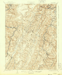 1924 Horton1924 Print · USGSRandolph and Tucker Counties were at the height of their rail-and-timber era in the early twenties. Researchers can trace family sites like Little Italy, industrial hubs at Whitmer, and rural landmarks such as Bethel Church or the Mylius School.2 unique versions available
End of results
Showing maps 1-2 of 2
Top cities near Harman
- Parsons historical maps
- Davis historical maps
- Thomas historical maps
- Hendricks historical maps
- Hambleton historical maps
Frequently asked questions
- What are the different types of historical maps available for Harman?
- What is the oldest map of Harman?
- Where can I purchase historical maps of Harman for my home or office?
- Where can I download high-res historical maps of Harman?
- Are there historical topographic maps available for Harman?
- Is there historical aerial imagery available for Harman?
- Where are historical maps of Harman sourced from?