1900s (20th Century) Maps of Spangler, West Virginia
Explore 9 historic maps of Spangler from the 1900s (20th Century). These maps offer a rare glimpse into what life looked like during the 1900s — showing old roads, neighborhoods, homes, and landmarks that have changed or disappeared over time.
Whether you're researching your family's past, planning a metal detecting trip, or studying how Spangler's landscape evolved across the 1900s, these high-resolution maps are a powerful tool for exploring the history of this region.
- Focus on a specific era: All maps on this page are from the 1900s, giving you a focused view of this time period.
- See what’s changed: Compare century-old streets, trails, and buildings to today's modern landscape using overlays and satellite layers.
- Research with precision: Use these maps for genealogy, historical research, land use analysis, or educational projects.
- View, download, or print: Maps are fully viewable online in high resolution, and can be downloaded or printed for your own records.
Start exploring Spangler's history through authentic maps from the 1900s. This is your window into the past.
Spangler, WV maps
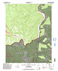
(9)- 1913 Map of Pickens
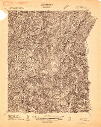 1913 Pickens1913 Print · USGSRandolph and Webster counties are shown here just before the Great War, during a peak era for mountain logging and rail expansion. Researchers can trace the routes of the Pickens and Hacker Valley RR and find local landmarks like Palace Valley, Lewis School, and Big Laurel Thicket.4 unique versions available
 - 1915 Map of Pickens
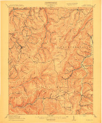 1915 Pickens1915 Print · USGSWest Virginia's highland timber country comes into focus during the early twentieth century as logging railroads began to penetrate the deep hollows. Trace the history of mountain settlements and schools like Helvetia, Pickens, and the Haslebacher School amidst the ridges of Beech Mountain.4 unique versions available
 - 1954 Map of Charleston
 1954 Charleston1954 Print · USGSWest Virginia’s industrial heart and mountain highlands are captured here during the mid-fifties, centered on the capital city. Researchers can trace historic river-and-rail corridors along the Kanawha River and locate remote peaks within the Monongahela National Forest.
 - 1957 Map of Charleston, 1966 Print
 1957 Charleston1966 Print · USGSMid-century West Virginia unfolds along the industrial Kanawha River valley and into the high Allegheny Mountains. Genealogists and historians can trace the vital rail lines of the Chesapeake and Ohio and locate riverside settlements from Saint Albans to Buckhannon.3 unique versions available
 - 1958 Map of Charleston
 1958 Charleston1958 Print · USGSMid-century West Virginia is defined here by the industrial corridor of the Kanawha River and the high ridges of the Allegheny Mountains. Researchers can trace the rail networks of the New York Central or locate remote highland communities like Pickens and Hillsboro.
 - 1961 Map of Charleston
 1961 Charleston1961 Print · USGSWest Virginia's capital region and the highlands to the east are shown in detail during the early sixties. Genealogists and historians can trace rail networks like the Baltimore and Ohio RR and find early state parks such as Watoga State Park.
 - 1977 Map of Valley Head
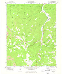 1977 Valley Head1977 Print · USGSRandolph County in the 1970s shows a landscape of steep timberlands and river-bottom settlements along the Tygart Valley River. Researchers can locate family landmarks like the Stalnaker Cem, Oakgrove Ch, and the high pass at Brady Gate.2 unique versions available
 - 1981 Map of Sutton, 1982 Print
 1981 Sutton1982 Print · USGSCentral West Virginia's mountain ridges and river valleys are captured here during the early eighties, as Interstate 79 began to modernize the region. Trace old rail lines like the Western Maryland Railway or explore the terrain around Sutton Lake and Helvetia.
 - 1995 Map of Valley Head, 1998 Print
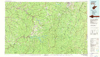
 1995 Valley Head1998 Print · USGSThe Tygart Valley River headwaters near Valley Head were documented in the mid-1990s as the high-elevation forest lands transitioned. Genealogists can locate family landmarks like Stalnaker Cem and Ware Cem alongside small communities like Monterville and Blue Spring.
End of results
Showing maps 1-9 of 9
Top cities near Spangler
- Mill Creek historical maps
- Valley Bend historical maps
- East Dailey historical maps
- Durbin historical maps
- Huttonsville historical maps
- Valley Head historical maps
See more
Frequently asked questions
- What are the different types of historical maps available for Spangler?
- What is the oldest map of Spangler?
- Where can I purchase historical maps of Spangler for my home or office?
- Where can I download high-res historical maps of Spangler?
- Are there historical topographic maps available for Spangler?
- Is there historical aerial imagery available for Spangler?
- Where are historical maps of Spangler sourced from?