1910s Maps of Crumps Bottom, West Virginia
Explore 2 historic maps of Crumps Bottom from the 1910s. These maps offer a rare glimpse into what life looked like during the 1910s — showing old roads, neighborhoods, homes, and landmarks that have changed or disappeared over time.
Whether you're researching your family's past, planning a metal detecting trip, or studying how Crumps Bottom's landscape evolved across the 1910s, these high-resolution maps are a powerful tool for exploring the history of this region.
- Focus on a specific era: All maps on this page are from the 1910s, giving you a focused view of this time period.
- See what’s changed: Compare century-old streets, trails, and buildings to today's modern landscape using overlays and satellite layers.
- Research with precision: Use these maps for genealogy, historical research, land use analysis, or educational projects.
- View, download, or print: Maps are fully viewable online in high resolution, and can be downloaded or printed for your own records.
Start exploring Crumps Bottom's history through authentic maps from the 1910s. This is your window into the past.
Crumps Bottom, WV maps
(2)- 1912 Map of Big Bend, 1964 Print
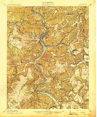
 1912 Big Bend1964 Print · USGSSummers County at the height of the steam era reveals a landscape shaped by the meeting of the Greenbrier and New Rivers. You can trace the path of the Chesapeake and Ohio RR through the Big Bend Tunnel or locate long-lost rural schools like Rock Bottom School and Spicklick School.
 - 1914 Map of Big Bend
 1914 Big Bend1914 Print · USGSIn the early twentieth century, the New River valley was a bustling corridor defined by its railroads and mountain settlements. Genealogists can trace family footprints at Packs Ferry PO, the Big Bend Tunnel, and numerous rural sites like Indian Mills.4 unique versions available
End of results
Showing maps 1-2 of 2
Top cities near Crumps Bottom
- Princeton historical maps
- Pearisburg historical maps
- Hinton historical maps
- Narrows historical maps
- Athens historical maps
- Pembroke historical maps
See more
Frequently asked questions
- What are the different types of historical maps available for Crumps Bottom?
- What is the oldest map of Crumps Bottom?
- Where can I purchase historical maps of Crumps Bottom for my home or office?
- Where can I download high-res historical maps of Crumps Bottom?
- Are there historical topographic maps available for Crumps Bottom?
- Is there historical aerial imagery available for Crumps Bottom?
- Where are historical maps of Crumps Bottom sourced from?