1990s Maps of Thomas, West Virginia
Explore 4 historic maps of Thomas from the 1990s. These maps offer a rare glimpse into what life looked like during the 1990s — showing old roads, neighborhoods, homes, and landmarks that have changed or disappeared over time.
Whether you're researching your family's past, planning a metal detecting trip, or studying how Thomas's landscape evolved across the 1990s, these high-resolution maps are a powerful tool for exploring the history of this region.
- Focus on a specific era: All maps on this page are from the 1990s, giving you a focused view of this time period.
- See what’s changed: Compare century-old streets, trails, and buildings to today's modern landscape using overlays and satellite layers.
- Research with precision: Use these maps for genealogy, historical research, land use analysis, or educational projects.
- View, download, or print: Maps are fully viewable online in high resolution, and can be downloaded or printed for your own records.
Start exploring Thomas's history through authentic maps from the 1990s. This is your window into the past.
Thomas, WV maps
(4)- 1995 Map of Davis, 1998 Print
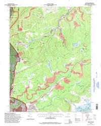 1995 Davis1998 Print · USGSThe West Virginia highlands in the mid-nineties reveal a landscape shaped by coal and timber along the Blackwater River. Trace family history at Thomas Cem or locate industrial sites like the strip mines and tipple near Henry.
 - 1995 Map of Blackwater Falls, 1998 Print
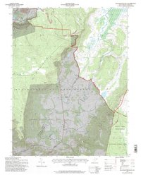 1995 Blackwater Falls1998 Print · USGSThe West Virginia highlands in the mid-nineties reveal a landscape of vast state parks and small mountain settlements. Researchers can locate remote family cemeteries, trace the old Cheat Potomac Rd, and see the footprint of local industry at the strip mine or Quarry.2 unique versions available
 - 1995 Map of Lead Mine, 1998 Print
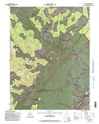 1995 Lead Mine1998 Print · USGSTucker County and the Monongahela National Forest are shown in the mid-nineties as the industrial and natural landscapes converged. Genealogists can trace family landmarks like Sugarland Ch Cem while historians locate coal works at Coketon and Thomas.
 - 1995 Map of Mozark Mountain, 1998 Print
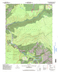 1995 Mozark Mountain1998 Print · USGSTucker County during the mid-1990s reveals a landscape defined by the convergence of mountain forks and deep wilderness protection. Genealogists and hikers can trace the connections between the riverside settlement of Hendricks, the remote community of Gladwin, and landmarks like Brights Chapel.2 unique versions available
End of results
Showing maps 1-4 of 4
Top cities near Thomas
- Parsons historical maps
- Rowlesburg historical maps
- Davis historical maps
- Hendricks historical maps
- Bayard historical maps
- Hambleton historical maps
See more
Top neighborhoods of Thomas
Frequently asked questions
- What are the different types of historical maps available for Thomas?
- What is the oldest map of Thomas?
- Where can I purchase historical maps of Thomas for my home or office?
- Where can I download high-res historical maps of Thomas?
- Are there historical topographic maps available for Thomas?
- Is there historical aerial imagery available for Thomas?
- Where are historical maps of Thomas sourced from?