1920s Maps of Palestine, West Virginia
Explore 2 historic maps of Palestine from the 1920s. These maps offer a rare glimpse into what life looked like during the 1920s — showing old roads, neighborhoods, homes, and landmarks that have changed or disappeared over time.
Whether you're researching your family's past, planning a metal detecting trip, or studying how Palestine's landscape evolved across the 1920s, these high-resolution maps are a powerful tool for exploring the history of this region.
- Focus on a specific era: All maps on this page are from the 1920s, giving you a focused view of this time period.
- See what’s changed: Compare century-old streets, trails, and buildings to today's modern landscape using overlays and satellite layers.
- Research with precision: Use these maps for genealogy, historical research, land use analysis, or educational projects.
- View, download, or print: Maps are fully viewable online in high resolution, and can be downloaded or printed for your own records.
Start exploring Palestine's history through authentic maps from the 1920s. This is your window into the past.
Palestine, WV maps
(2)- 1924 Map of Elizabeth, 1965 Print
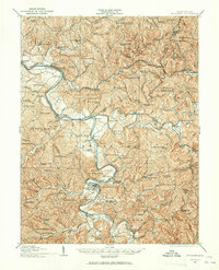 1924 Elizabeth1965 Print · USGSWirt and Wood Counties come alive in the mid-1920s as the Little Kanawha River serves as the primary artery for local life and industry. Genealogists can trace hundreds of family sites near schools like Mountain Flower School or the rural Antioch Church.
 - 1926 Map of Elizabeth
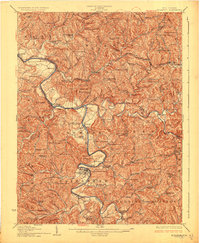 1926 Elizabeth1926 Print · USGSMid-century West Virginia hill country comes to life here along the banks of the Little Kanawha River and the Baltimore and Ohio line. Genealogists can trace a remarkable landscape of rural education through Rising Sun School, Mountain Flower School, and Muddy Cut School.3 unique versions available
End of results
Showing maps 1-2 of 2
Top cities near Palestine
Frequently asked questions
- What are the different types of historical maps available for Palestine?
- What is the oldest map of Palestine?
- Where can I purchase historical maps of Palestine for my home or office?
- Where can I download high-res historical maps of Palestine?
- Are there historical topographic maps available for Palestine?
- Is there historical aerial imagery available for Palestine?
- Where are historical maps of Palestine sourced from?