1900s (20th Century) Maps of Tralee, West Virginia
Explore 10 historic maps of Tralee from the 1900s (20th Century). These maps offer a rare glimpse into what life looked like during the 1900s — showing old roads, neighborhoods, homes, and landmarks that have changed or disappeared over time.
Whether you're researching your family's past, planning a metal detecting trip, or studying how Tralee's landscape evolved across the 1900s, these high-resolution maps are a powerful tool for exploring the history of this region.
- Focus on a specific era: All maps on this page are from the 1900s, giving you a focused view of this time period.
- See what’s changed: Compare century-old streets, trails, and buildings to today's modern landscape using overlays and satellite layers.
- Research with precision: Use these maps for genealogy, historical research, land use analysis, or educational projects.
- View, download, or print: Maps are fully viewable online in high resolution, and can be downloaded or printed for your own records.
Start exploring Tralee's history through authentic maps from the 1900s. This is your window into the past.
Tralee, WV maps
(10)- 1902 Map of Raleigh
 1902 Raleigh1902 Print · USGSRaleigh County and the New River Gorge were entering their industrial peak when this survey was conducted in the late nineteenth century. Researchers can trace the early rail network of the CHESAPEAKE AND OHIO RR through booming towns like Thurmond, Beury, and East Sewell.3 unique versions available
 - 1912 Map of Mullens
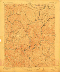 1912 Mullens1912 Print · USGSThe Raleigh and Wyoming county lines meet in this 1910 study of the West Virginia coalfields during a period of rapid industrial growth. Genealogists and historians can trace the early path of the Virginian RR and locate vanished company towns like Stotesbury, Glen White, and Hotchkiss.2 unique versions available
 - 1925 Map of Mullens, 1958 Print
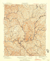 1925 Mullens1958 Print · USGSWest Virginia's coal country comes into sharp focus during the mid-twenties as the Virginian Railway connects mountain hollows. Genealogists can locate family homes near Taliaferro School, Stotesbury, and Glen Rogers along the Guyandot River.2 unique versions available
 - 1927 Map of Mullens
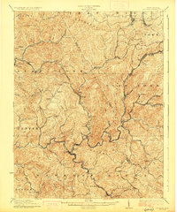 1927 Mullens1927 Print · USGSSouthern West Virginia’s coal country is shown at its industrial height during the mid-1920s, dominated by the winding path of the Virginian railway. Genealogists can trace hundreds of homes and landmarks in company towns like Mullens, Tams, and Stotesbury.2 unique versions available
 - 1955 Map of Bluefield
 1955 Bluefield1955 Print · USGSThe Central Appalachian borderlands come alive in the mid-fifties, showing the coal and rail networks connecting Bluefield to Beckley. Researchers can trace the industrial landscape of the New River Ordnance Plant and the terrain of Burkes Garden.
 - 1957 Map of Bluefield, 1967 Print
 1957 Bluefield1967 Print · USGSThe heart of Central Appalachia in the mid-fifties is defined by the winding rail lines and river valleys of the coalfields. Researchers can trace the industrial footprints of towns like Welch and Princeton or locate landmarks such as the Bluestone Reservoir and Claytor Lake.2 unique versions available
 - 1961 Map of Bluefield
 1961 Bluefield1961 Print · USGSThe coalfields and mountain ridges of southern West Virginia and southwest Virginia are captured in the early sixties. Genealogists can trace family ties through rail-linked towns like Princeton and Richlands or along the shores of Bluestone Reservoir.
 - 1967 Map of Mullens, 1971 Print
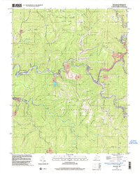
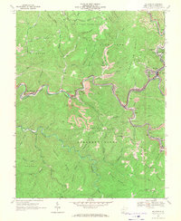 1967 Mullens1971 Print · USGSThe West Virginia coalfields are in full operation during the late sixties as the Norfolk and Western railway snakes through the Guyandotte River valley. Trace family roots and local industry in Mullens, Itmann, and Tralee, or locate rural landmarks like Slab Fork Sch and Bower Cem.2 unique versions available
 - 1982 Map of Beckley, 1984 Print
 1982 Beckley1984 Print · USGSSouthern West Virginia coal country is captured here in the early eighties as industrial heritage met new wilderness protections. Genealogists and historians can trace the rail-linked communities of Beckley, Oak Hill, and the coal camps near Macdonald.
 - 1996 Map of Mullens, 2003 Print
 1996 Mullens2003 Print · USGSCoal and rail define this Wyoming County landscape during the late 1990s as the Norfolk and Western RR winds through the Guyandotte River valley. Genealogists and historians can trace community roots through local landmarks like Conley Sch, Nuriva, and the many family-named cemeteries and Mines along the ridges.
End of results
Showing maps 1-10 of 10
Top cities near Tralee
- Beckley historical maps
- Welch historical maps
- Mullens historical maps
- Oceana historical maps
- Mabscott historical maps
- Sophia historical maps
See more
Frequently asked questions
- What are the different types of historical maps available for Tralee?
- What is the oldest map of Tralee?
- Where can I purchase historical maps of Tralee for my home or office?
- Where can I download high-res historical maps of Tralee?
- Are there historical topographic maps available for Tralee?
- Is there historical aerial imagery available for Tralee?
- Where are historical maps of Tralee sourced from?